Mini-Me: GoogleMaps Add Elevation — Good-Bye National Geospatial Agency? Can Tiling Extend to All-Source Data M4IS2/OSE?

Analysis, Earth Orientation, Geospatial, Geospatial
Who, Mini-Me?
Who, Mini-Me?

Huh?

Google Maps Now Show Elevation Statistics For Bikers

Google, the world's largest internet search operator, is bringing one of the most useful features to bikers using its Google Maps service. While cycling can be fun, sometimes an arbitrary hill climb can be a challenging task. But it appears that Google has finally come up with a fix for that, not essentially helping you get the bike to the top of the hill, but by showing an upcoming elevation in Google Maps' bike routes. The app now features elevation statistics to help bikers tackle steep hills.

Google did not officially announce the feature but confirmed to TechCrunch that the addition is indeed new to Maps. The Mountain View, California based tech giant has offered GPS functionality for bikers for few years now, but helped not more than being a map.

Click on Image to Enlarge

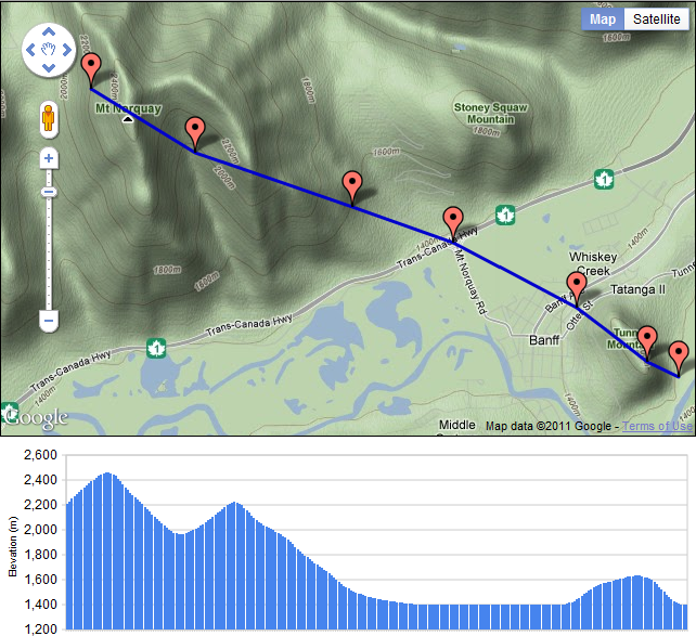
Bikers can simple select a bike route on the map and Google will find the directions for the destination. Following the update, information showing an elevation and descent will populate. In addition to the graphical representation of the hill, Google also displays a card to show the number of feet a biker must climb before reaching the top and descend through the other side.

Google will not display any elevation statistics when bikers are riding on flat roads. Google also confirmed to the tech blog that the new feature is available in all 14 countries where the biking directions are available on Maps, including Austria, Australia, Belgium, Canada, Switzerland, Germany, Denmark, Finland, Great Britain, Netherlands, Norway, New Zealand, Sweden and the US.

Google has been updating its mapping service quite frequently, of late. Earlier this month, the web giant added offline support for Google Maps, integrated Uber taxi service, improved local business search and more. These changes show how badly Google wants to stay ahead of its rivals, such as Nokia and Apple. The addition of more features to make the service useful for end users is surely an added advantage.

Continue reading “Mini-Me: GoogleMaps Add Elevation — Good-Bye National Geospatial Agency? Can Tiling Extend to All-Source Data M4IS2/OSE?”

Graphic: Persistent Surveillance Stoplight Chart

Analysis, Balance, Capabilities-Force Structure, Collection, Corruption, Geospatial, ICT-IT, Processing, Reform, Strategy-Holistic Coherence, Threats, True Cost
Click on Image to Enlarge

PPT: Single Source Evaluation Matrix 1.2

See Also:

Analysis @ Phi Beta Iota

Big Data @ Phi Beta Iota

Yoda: Exascale by 2020? No Way, Jose! Four Socko Graphics and Bottom Line Upfront — Human Brain Still a Million Times More Power Efficient

Neal Rauhauser: Central African Republic Maps

Analysis, Citizen-Centered, Geospatial, Languages-Translation, Tribes, True Cost, United Nations
Neal Rauhauser
Neal Rauhauser

Updated Central African Republic Maps

The Central African Republic’s troubles were obvious to foreign policy watchers a year ago and now conflict has boiled over into outright ethnic cleansing. As a former French colony the best sources on this area are still in French and as a resource poor, land locked area there simply wasn’t much available in February of last year. Now that things have gotten really bad some new maps have emerged.

I would normally provide some sort of unifying commentary for a collection of maps. All I have to offer today is that someone commented on the lack of quality maps for the Central African Republic, and I decided to go digging.

Click on Image to Enlarge

See other graphic maps.

Graphic: Object Based Information Organization

Analysis
Click on Image to Enlarge

Source

Phi Beta Iota: Very interesting — and what some of us have been asking for since 1988. A few small obstacles, such as over 2,500 compartments that do not share, over 80 different databases that still cannot be accessed simultaneously, and the rather frightening reality that annual collection of “everything” is a mega-petabyte endeavor that our existing processing systems — and all existing cloud systems — simply cannot handle.  Still and all, a very important slide with a good intention.

Graphic: Activity-Based Intelligence

Analysis
Click on Image to Enlarge

Source

Phi Beta Iota: When you can achieve persistent surveillance AND you have the analytic software AND you have analysts trained to think in new ways THEN you get some really remarkable TACTICAL break-throughs. This is not the panacea some are claiming; it does nothing for strategic, policy, acquisition, or theater operations analytics. What is most interesting about this is that it can, when managed properly and when the theater commander is mandating collaboration (rarely the case), become the de facto all source fusion collection manager. This is also — again at the tactical level — a very positive development when you are sending teams into places that the NRO, NSA, NGA, CIA and others have been ignoring since WWII — within 30 days you can have extraordinary baselines that are simply not achievable with national systems.