Berto Jongman: Social Media and the Emergence of Open-Source Geospatial Intelligence

Crowd-Sourcing, Geospatial
Berto Jongman
Berto Jongman

Social Media and the Emergence of Open-Source Geospatial Intelligence

We have just finished a paper entitled ‘Social Media and the Emergence of Open-Source Geospatial Intelligence' for Socio-Cultural Dynamics and Global Security. For those interested below is the abstract:

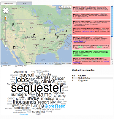
The emergence of social media has provided the public with an effective and irrepressible real-time mechanism to broadcast information. The great popularity of platforms such as twitter and YouTube, and the substantial amount of content that is communicated through them are making social media an essential component of open-source intelligence. The information communicated through such feeds conveys the interests and opinions of individuals, and reveals links and the complex structure of social networks.

Click on Image to Enlarge

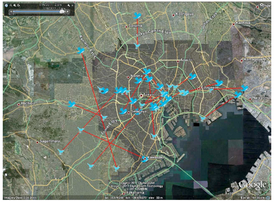
However, this information is only partially exploited if one does not consider its geographical aspect. Indeed, social media feeds more often than not have some sort of geographic content, as they may communicate the location from where a particular report is contributed, the geolocation of an image, or they may refer to a specific sociocultural hotspot. By harvesting this geographic content from social media feeds we can transfer the extracted knowledge from the amorphous cyberspace to the geographic space, and gain a unique understanding of the human lansdscape, its structure and organization, and its evolution over time. This new-found opportunity signals the emergence of open-source geospatial intelligence, whereby social media contributions can be analyzed and mined to gain unparalleled situational awareness. In this paper we showcase a number of sample applications that highlight the capabilities of harvesting geospatial intelligence from social media feeds, focusing particularly on twitter as a representative data source.

Continue reading “Berto Jongman: Social Media and the Emergence of Open-Source Geospatial Intelligence”

Patrick Meier: Jointly: Peer-to-Peer Disaster Recovery App

Crowd-Sourcing, Geospatial, P2P / Panarchy
Patrick Meier
Patrick Meier

Jointly: Peer-to-Peer Disaster Recovery App

My colleague Samia Kallidis is launching a brilliant self-help app to facilitate community-based disaster recovery efforts. Samia is an MFA Candidate at the School of Visual Arts in New York. While her work on this peer-to-peer app began as part of her thesis, she has since been accepted to the NEA Studio Incubator Program to make her app a reality. NEA provides venture capital to help innovative entrepreneurs build transformational initiatives around the world. So huge congrats to Samia on this outstanding accomplishment. I was already hooked back in February when she presented her project at NYU and am even more excited now. Indeed, there are exciting synergies with the MatchApp project I’m working on with QCRI and MIT-CSAIL , which is why we’re happily exploring ways to collaborate & complement our respective initiatives.

Read full post with multiple graphics.

Patrick Meier: Social Media for Emergency Management

Crowd-Sourcing, Geospatial
Patrick Meier
Patrick Meier

Social Media for Emergency Management: Question of Supply and Demand

I’m always amazed by folks who dismiss the value of social media for emergency management based on the perception that said content is useless for disaster response. In that case, libraries are also useless (bar the few books you’re looking for, but those rarely represent more than 1% of all the books available in a major library). Does that mean libraries are useless? Of course not. Is social media useless for disaster response? Of course not. Even if only 0.001% of the 20+ million tweets posted during Hurricane Sandy were useful, and only half of these were accurate, this would still mean over 1,000 real-time and informative tweets, or some 15,000 words—i.e., the equivalent of a 25-page, single-space document exclusively composed of fully relevant, actionable & timely disaster information.

Read full post.

Patrick Meier: Introducing MicroMappers for Digital Disaster Response

Crowd-Sourcing, Geospatial
Patrick Meier
Patrick Meier

Introducing MicroMappers for Digital Disaster Response

The UN activated the Digital Humanitarian Network (DHN) on December 3, 2012 to carry out a rapid damage needs assessment in response to Typhoon Pablo in the Philippines. More specifically, the UN requested that Digital Humanitarians collect and geo-reference all tweets with links to pictures or video footage capturing Typhoon damage. To complete this mission, I reached out to my colleagues at CrowdCrafting. Together, we customized a microtasking app to filter, classify and geo-reference thousands of tweets. This type of rapid damage assessment request was the first of its kind, which means that setting up the appropriate workflows and technologies took a while, leaving less time for the tagging, verification and analysis of the multimedia content pointed to in the disaster tweets. Such is the nature of innovation; optimization takes place through iteration and learning.

Read full post.

Bonnie Hoffhof: GIS and Agent-Based Modeling – GeoSocial Guage

Crowd-Sourcing, Geospatial
Bonnie Hohhof
Bonnie Hohhof

Over the last couple of months we have been working on getting our GeoSocial Gauge system up and running. The idea behind the website is to bring together social media and geographical analysis to monitor and explore people’s views, reactions, and interactions through space and time. It takes advantage of the emergence of social media to observe the human landscape as the living, breathing organism that it is: we can witness the explosion-like dissemination of information within a society, or the clusters of individuals who share common opinions or attitudes, and map the locations of these clusters. This is an unprecedented development that broadens drastically our understanding of the way that people act, react to events, and interact with each other and with their environment. We refer to this novel approach to study the integration of geography and society as GeoSocial Analysis.

gis screen shotThe GeoSocial Gauge has several live streams ranging from exploring the political issues (e.g. Sequester) to to see what people are tweeting about TV (The Walking Dead).

Phi Beta Iota:  Some very interesting spontaneous combustion is happening, with convergence slow but sure to come.

See Also:

DuckDuckGo / Crisis Mapping

DuckDuckGo / Patrick Meier

Google launches global hotline to combat human trafficking

Patrick Meier: Humanitarianism in the Network Age: Groundbreaking Study

Crowd-Sourcing, Geospatial, Governance, Innovation, United Nations & NGOs
Patrick Meier
Patrick Meier

Humanitarianism in the Network Age: Groundbreaking Study

My colleagues at the United Nations Office for the Coordination of Humanitarian Affairs (OCHA) have just published a groundbreaking must-read study on Humanitarianism in the Network Age; an important and forward-thinking policy document on humanitarian technology and innovation. The report “imagines how a world of increasingly informed, connected and self-reliant communities will affect the delivery of humanitarian aid. Its conclusions suggest a fundamental shift in power from capital and headquarters to the people [that] aid agencies aim to assist.” The latter is an unsettling prospect for many. To be sure, Humanitarianism in the Network Age calls for “more diverse and bottom-up forms of decision-making—something that most Governments and humanitarian organizations were not designed for. Systems constructed to move information up and down hierarchies are facing a new reality where information can be generated by any-one, shared with anyone and acted by anyone.”

The purpose of this blog post (available as a PDF) is to summarize the 120-page OCHA study. In this summary, I specifically highlight the most important insights and profound implications. I also fill what I believe are some of the report’s most important gaps. I strongly recommend reading the OCHA publication in full, but if you don’t have time to leaf through the study, reading this summary will ensure that you don’t miss a beat. Unless otherwise stated, all quotes and figures below are taken directly from the OCHA report.

Read full post.

Patrick Meier: Automatically Extracting Disaster-Relevant Information from Social Media

Crowd-Sourcing, Geospatial
Patrick Meier
Patrick Meier

Automatically Extracting Disaster-Relevant Information from Social Media

My team and I at QCRI have just had this paper (PDF) accepted at the World Wide Web (WWW 2013) conference in Rio next month. The paper relates directly to our Artificial Intelligence for Disaster Response (AIDR) project. One of our main missions at QCRI is to develop open source and freely available next generation humanitarian technologies to better manage Big (Crisis) Data. Over 20 million tweets and half-a-million Instagram pictures were posted during Hurricane Sandy, for example. In Japan, more 2,000 tweets were posted every second the day after the devastating earthquake and Tsunami struck the Eastern Coast. Recent empirical studies have shown that an important percentage of tweets posted during disaster are informative and even actionable. The challenge before is how to find those proverbial needles in the haystack and to do so in as close to real-time as possible.

So we analyzed disaster tweets posted during Hurricane Sandy (2012) and the Joplin Tornado (2011). We demonstrate that disaster-relevant information can be automatically extracted from these datasets. The results indicate that 40% to 80% of tweets that contain disaster-related information can be automatically detected. We also demonstrate that we can correctly identify the type of disaster information 80% to 90% of the time. Because these classifiers are developed using machine learning, they get more accurate with more data. This explains why we are building AIDR. Our aim is not to replace human involvement and oversight but to significantly lessen the load on humans.

Read full post.