Patrick Meier: An Introduction to Humanitarian UAVs – Comment by Robert Steele

Access, Architecture, Data, Design, Geospatial, Resilience, SmartPlanet, Sources (Info/Intel)
Patrick Meier
Patrick Meier

An Introduction to Humanitarian UAVs and their Many Uses

Satellite images have been used to support humanitarian efforts for decades. Why? A bird’s eye view of a disaster-affected area simply captures far more information than most Earth-based data-collection technologies can. In short, birds have more situational awareness than we do. In contrast to satellites, UAVs offer significantly higher-resolution imagery, are unobstructed by clouds, can be captured more quickly, by more groups and more often at a fraction of the cost with far fewer licensing and data-sharing restrictions than satellite imagery.

Introduction to UAVs

There are basically three types of UAVs: 1) the balloon/kite variety; 2) fixed-wing UAVs; 3) rotary-wing UAVs. While my forthcoming book looks at humanitarian applications of each type, I’ll focus on fixed-wing and rotary-wing UAVs here since these are of greatest interest to humanitarian organizations. These types of UAVs differ from traditional remote control planes and helicopters because they are programmable and intelligent. UAVs can be programmed to take-off, fly and land completely autonomously, for example. They often include intelligent flight stabilization features that adapt for changing wind speeds and other weather-related conditions. They also have a number of built-in fail-safe mechanisms; some of the newer UAVs even include automated collision avoidance systems.

Click on Image to Enlarge

Fixed-wing UAVs like senseFly’s eBees (above) are launched by hand and can land a wide variety of surfaces, requiring only a few meters of landing space. They fly autonomously along pre-programmed routes and also land themselves auto-matically. My colleague Adam from senseFly recently flew eBees to support recovery efforts in the Philippines following Typhoon Yolanda. Adam is also on the Advisory Board of the Humanitarian UAV Network (UAViators). Other fixed-wing UAVs are flown manually and require an airstrip for both manual take-off and landing. Rotary-wing UAVs, in contrast, are “helicopters” with three or more propellors. Quadcopters, for example, have four propellors, like the Huginn X1 below, which my colleague Liam Dawson, another Advisory Board member, flew following Typhoon Yolanda in the Philippines. One advantage of rotary-UAVs is that they take-off and land vertically. They can also hover in one fixed place and can also be programmed to fly over designated points.

Click on Image to Enlarge

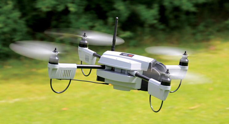
Rotary-UAVs cannot glide like their fixed-wing counterparts, which means their batteries get used up fairly quickly. So they can’t stay airborne for very long (~25 minutes, 2 kilometer range, depending on the model) compared to fixed-wing UAVs like the eBee (~45 minutes, 3 kilometers). Advisory Board member Shane Coughlan is designing fixed-wing humanitarian UAVs that will have a range of several hundred kilometers. Fixed-wing UAVs, however, cannot hover in one place over time. So both types of UAVs come with their advantages and disadvantages. Most UAV experts agree that fixed-wing and rotary-wing UAVs can serve complementary purposes, however. You can quickly use a quadcopter to an initial aerial recon and then send a fixed-wing UAV for more detailed, high-resolution imagery capture.

Humanitarian Uses of UAVs

Continue reading “Patrick Meier: An Introduction to Humanitarian UAVs – Comment by Robert Steele”

Berto Jongman: Helsinki the World’s Most Successful Open Data City

Data
Berto Jongman
Berto Jongman

How Helsinki Became the Most Successful Open-Data City in the World

HELSINKI, Finland — If there's something you'd like to know about Helsinki, someone in the city administration most likely has the answer. For more than a century, this city has funded its own statistics bureaus to keep data on the population, businesses, building permits, and most other things you can think of. Today, that information is stored and freely available on the internet by an appropriately named agency, City of Helsinki Urban Facts.

There's a potential problem, though. Helsinki may be Finland's capital and largest city, with 620,000 people. But it’s only one of more than a dozen municipalities in a metropolitan area of almost 1.5 million. So in terms of urban data, if you're only looking at Helsinki, you’re missing out on more than half of the picture.

Helsinki and three of its neighboring cities are now banding together to solve that problem. Through an entity called Helsinki Region Infoshare, they are bringing together their data so that a fuller picture of the metro area can come into view.

That’s not all. At the same time these datasets are going regional, they're also going “open.” Helsinki Region Infoshare publishes all of its data in formats that make it easy for software developers, researchers, journalists and others to analyze, combine or turn into web-based or mobile applications that citizens may find useful. In four years of operation, the project has produced more than 1,000 “machine-readable” data sources such as a map of traffic noise levels, real-time locations of snow plows, and a database of corporate taxes.

A global leader

All of this has put the Helsinki region at the forefront of the open-data movement that is sweeping cities across much of the world. The concept is that all kinds of good things can come from assembling city data, standardizing it and publishing it for free. Last month, Helsinki Region Infoshare was presented with the European Commission's prize for innovation in public administration.

Read rest of article.

Stephen E. Arnold: “Business Intelligence” aka Data Mining Marketplace Imploding — “Everything Must Go!”

Data, IO Impotency
Stephen E. Arnold
Stephen E. Arnold

Tibco, Business Intelligence, and Open Source—Not Search

I read “Consolidation Looms in Business Intelligence, as Tibco Buys Jaspersoft for $185M.” The write up is interesting, but not exactly congruent with my views. May I explain?

The article points out:

Enterprise software vendor TIBCO has acquired Jaspersoft, an open source business intelligence company, for approximately $185 million. It’s not an earth-shaking deal, but it could be a sign of things to come in an analytics software market full of companies and products that have a hard time standing out from the crowd.

MBAs will drooling at the thought of business intelligence deal making if the article’s premise is correct.

But there are several other angles in this Tibco Jaspersoft tie up.

Continue reading “Stephen E. Arnold: “Business Intelligence” aka Data Mining Marketplace Imploding — “Everything Must Go!””

Stephen E. Arnold: Search Big Data Flim-Flam – And One Open Source Search of Compressed Files with SQL (RainStor)

Data
Stephen E. Arnold
Stephen E. Arnold

Search and Big Data: Been There, Done That

Is the use of search to find information in large collections of content revolutionary? Er, no. What about using search to locate an Internet Protocol address in a repository of monitored email traffic? Er, no.

With the chatter on LinkedIn and the vacuous news releases from some floundering search companies, one would think that gathering up content and running a query was the equivalent of my ancestor stealing and ember and saying, “Look, I invented fire.”

Sorry.

Beyond the rather influential if specious IBM white paper published in 2010 (link is at http://bit.ly/1gckiPJ), a large number of companies continue to position some old as new again.

One interesting twist on the “search is better than SQL” is the useful solution brief from RainStor. In some circles, RainStor has a low profile. In others, the company has caught the attention of some recognized “names” in the Big Data world; for example, Cloudera and Dell. So think Hadoop friendly.

Continue reading “Stephen E. Arnold: Search Big Data Flim-Flam – And One Open Source Search of Compressed Files with SQL (RainStor)”

Yoda: US Government Gets It Right on Open Data

Data
Got Crowd? BE the Force!

Open Data Law Aims To Demystify Federal Spending

Landmark DATA legislation, near passage, would transform the US government's spending information from a maze of confusing documents into easily accessible open data.

Both houses of Congress stand poised to pass a law three years in the making that would standardize how the federal government's spending data are published. The Digital Accountability and Transparency Act (DATA Act), regarded by some observers as the most significant open-government legislation since the Freedom of Information Act in 1966, would transform the US government's spending information from a maze of confusing documents into easily accessible open data.

The new law would require the federal government to automate, standardize, and publish its myriad financial management, procurement, and related data in electronic formats that can be easily accessed and analyzed by interested parties in the public and private sectors.

Read full article.

Stephen E. Arnold: New York Public Library Posts Open Maps

Access, Data, Geospatial
Stephen E. Arnold
Stephen E. Arnold

New York Public Library Posts Maps

The New York Public Library has a massive collection of beautiful maps, but instead of keeping them locked in an archive Motherboard reports, “The New York Public Library Releases 20,000 Beautiful High Resolution Maps.”

All of the 20,000 maps are available via open access. What is even more amazing is that the NYPL decided to release the maps under the Creative Commons CCO 1.0 Universal Public Domain Dedication. If you are unfamiliar with a Creative Commons license, it means that users are free to download content and do whatever they want with it.

Continue reading “Stephen E. Arnold: New York Public Library Posts Open Maps”

Stephen E. Arnold: USG Considers Open Acquisition

Data, Governance
Stephen E. Arnold
Stephen E. Arnold

Government Tackles Acquisition Inefficiencies

Given evidence like the vile backlog on veterans’ benefits and the still-operating paperwork bunker in Pennsylvania, one could be forgiven for suspecting that no one in government is even trying to bring our bureaucracy into this century. You may be surprised to know there is plan in place for at least part of the problem, as evidenced by the Integrated Award Environment: the Path Forward from the U.S. General Services Administration (GSA). That document, which looks suspiciously like a Power Point presentation converted to PDF, outlines the GSA’s recommendations for improving the federal government’s acquisition procedures.

Anyone interested in the details should check out the document, but the list of “our principles” summarizes the organization’s targets:

Continue reading “Stephen E. Arnold: USG Considers Open Acquisition”