The Multi-Cluster/Sector Initial Rapid Assessment (MIRA) is the methodology used by UN agencies to assess and analyze humanitarian needs within two weeks of a sudden onset disaster. A detailed overview of the process, methodologies and tools behind MIRA is available here (PDF). These reports are particularly insightful when comparing them with the processes and methodologies used by digital humanitarians to carry out their rapid damage assessments (typically done within 48-72 hours of a disaster).
Take the November 2013 MIRA report for Typhoon Haiyan in the Philippines. I am really impressed by how transparent the report is vis-à-vis the very real limitations behind the assessment. For example:
My QCRI colleagues Kiran Garimella and Ingmar Weber recently co-authored an important study on migration patterns discerned from Twitter. The study was co-authored with Bogdan State (Stanford) and lead author Emilio Zagheni (CUNY). The authors analyzed 500,000 Twitter users based in OECD countries between May 2011 and April 2013. Since Twitter users are not representative of the OECD population, the study uses a “difference-in-differences” approach to reduce selection bias when in out-migration rates for individual countries. The paper is available here and key insights & results are summarized below.
UAVs (or drones) are starting to be used for search & rescue operations, such as in the Philippines following Typhoon Yolanda a few months ago. They are also used to find missing people in the US, which may explain why members of the North Texas Drone User Group (NTDUG) are organizing the (first ever?) Search & Rescue challenge in a few days. The purpose of this challenge is to 1) encourage members to build better drones and 2) simulate a real world positive application of civilian drones.
I sometimes think I could drop all of my technical Twitter follows except for @kdnuggets and that would be more than enough to keep me busy. Today he mentioned MassBigData, a statewide initiative to open government data for exploitation. What used to happen inside 128 has spread as far west as Worcester.
. . . . . .
I’ve long advocated for expanding our national rail network and replacing the city networks, which once spanned the entire country from Long Island to Milwaukee. Here’s what the state of Massachusetts makes available in terms of transportation data as part of the initiative:
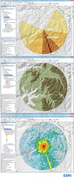
A little-known California company called Esri offers a “Facebook for Maps” that promises to change the way we interact with our environment, predict behavior, and make decisions in the decades ahead.
Click on Image to Enlarge
The setting is central California’s Yosemite National Park. A hiker, let’s call him Steve Clark, has gone missing on one of the trails. As the head park ranger, your job is to lead a search-and-rescue mission to find him. All you have to go on is the point where he was last seen, your training, and a computer; from this, you have to predict the behavior of a lost hiker. Sunset is approaching, and in some parts of the park the temperature will be below freezing in a matter of hours. What do you do?
Click on Image to Enlarge
Many experienced hikers know that the recommended course of action when lost is to follow a stream downhill and this will eventually lead to civilization. But you can’t assume that Steve Clark is aware of this, or that he’s even seen the Discovery Channel. He might elect to stay put, or, if he has a cell phone, he might be moving uphill to find a signal. You also don’t know if he’s injured. A person with a sprained ankle is less likely to walk up, but he may not move down, either.
You go to your computer and open ArcGIS.com. A computer map of Yosemite that you’ve made and uploaded appears on the screen. Let’s say you also have access to a “big data” database of records from 30,000 lost hiker search-and-rescue missions and you can query this database with key words.
You soon learn that 66% of lost hikers are found within two miles of the spot last seen. You impose a ring over your map reflecting this two-mile perimeter. You then learn that 52% of lost hikers are found downhill, only 32% go up, and 16% keep walking at the same elevation. You impose an elevation layer on the area with all the land above the last point seen shaded one color and the land beneath it shaded another. You can even impose a new lens depicting tree and plant cover and open fields, and one depicting linear objects like trails, roads, power lines, and streams, knowing that the vast majority of lost hikers follow some sort of linear marker to avoid going in circles.
Phi Beta Iota: ESRI code is proprietary and they do not play well with others. They either have to change both of those conditions, or be replaced by CrisisMappers at scale. The future is open. This is not negotiable.
iRevolution crossed the 1 million hits mark in 2013, so big thanks to iRevolution readers for spending time here during the past 12 months. This year also saw close to 150 new blog posts published on iRevolution. Here is a short selection of the Top 15 iRevolution posts of 2013:
I gave a talk on “The future of Humanitarian Response” at UN OCHA’s Global Humanitarian Policy Forum (#aid2025) in New York yesterday. More here for context. A similar version of the talk is available in the video presentation below.
Some of the discussions that ensued during the Forum were frustrating albeit an important reality check. Some policy makers still think that disaster response is about them and their international humanitarian organizations. They are still under the impression that aid does not arrive until they arrive. And yet, empirical research in the disaster literature points to the fact that the vast majority of survivals during disasters is the result of local agency, not external intervention.