
1:50,000 scale national “full” vector data of Syria, updated as of 2004-2006.
Email Geoff: gforbes@landinfo.com
Patrick Meier: Twitter as a Community Nervous System
Crowd-Sourcing, Culture, Data, Geospatial, Governance, P2P / Panarchy, Politics, Resilience, Transparency
Taking the Pulse of the Boston Marathon Bombings on Twitter
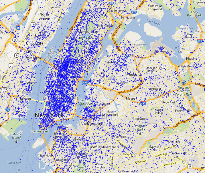
Social media networks are evolving a new nervous system for our planet. These real-time networks provide immediate feedback loops when media-rich societies experience a shock. My colleague Todd Mostak recently shared the tweet map below with me which depicts tweets referring to “marathon” (in red) shortly after the bombs went off during Boston’s marathon. The green dots represent all the other tweets posted at the time. Click on the map to enlarge. (It is always difficult to write about data visualizations of violent events because they don’t capture the human suffering, thus seemingly minimizing the tragic events).
Visualizing a social system at this scale gives a sense that we’re looking at a living, breathing organism, one that has just been wounded. This impression is even more stark in the dynamic visualization captured in the video below.
Patrick Meier: Radically Cool Access to Instagram Photos in Near Real Time, Panoramic or Deep
Crowd-Sourcing, Geospatial
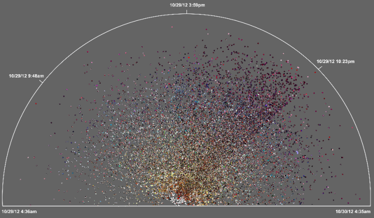
Radical Visualization of Photos Posted to Instagram During Hurricane Sandy
This data visualization (click to enlarge) displays more than 23,500 photos taken in Brooklyn and posted to Instagram during Hurricane Sandy. A picture’s distance from the center (radius) corresponds to its mean hue while a picture’s position along the perimeter (angle) corresponds to the time that picture was taken. ”Note the demarcation line that reveals the moment of a power outage in the area and indicates the intensity of the shared experience (dramatic decrease in the number of photos, and their darker colors to the right of the line)” (1).
Read full article with additional graphics.
Phi Beta Iota: Each dot is an actual photograph with time and space tag. It is the first step toward streaming video from aggregated individual hand-held camera shots.
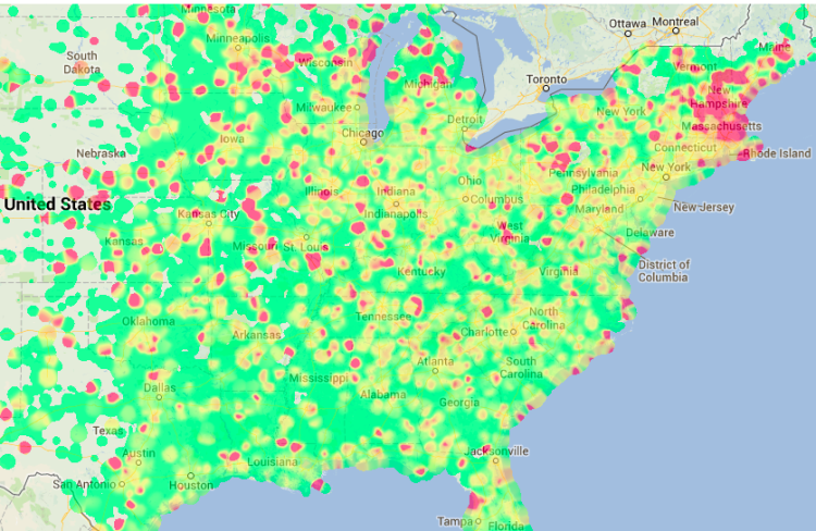
Patrick Meier: Tweet in New York — You ARE Being Tracked
Crowd-Sourcing, GeospatialMap: 24 hours of Tweets in New York
The map below depicts geo-tagged tweets posted between May 4-5, 2013 in the New York City area. Over 36,000 tweets are posted on the map (click to enlarge). Since less than 3% of all tweets are geo-tagged, the map is missing the vast majority of tweets posted in this area during those 24 hours.
. . . . . . .
These visuals are screenshots of Harvard’s Tweetmap platform, which is publicly available here. My colleague Todd Mostak is one of the main drivers behind Tweetmap, so worth sending him a quick thank you tweet! Todd is working on some exciting extensions and refinements, so stay tuned as I’ll be sure to blog about them when they go live.
Patrick Meier: First Spam Filter for Disaster Response — Multiple Humans, Automated Cross-Checking
Crowd-Sourcing, GeospatialThe First Ever Spam Filter for Disaster Response
While spam filters provide additional layers of security to websites, they can also be used to process all kinds of information. Perhaps most famously, for example, the reCAPTCHA spam filter was used to transcribe the New York Times’ entire paper-based archives. See my previous blog post to learn how this was done and how spam filters can also be used to process information for disaster response. Given the positive response I received from humanitarian colleagues who read the blog post, I teamed up with my colleagues at QCRI to create the first ever spam filter for disaster response.
. . . . . . .
The desired outcome? Each potential disaster picture is displayed to 3 different email account users. Only if each of the 3 users tag the same picture as capturing disaster damage does that picture get automatically forwarded to members of the Digital Humanitarian Network. To tag more pictures after logging in, users are invited to do so via MicroMappers, which launches this September in partnership with OCHA. MicroMappers enables members of the public to participate in digital disaster response efforts with a simple click of the mouse.
Patrick Meier: Disaster Response Plugin for Online Games
Crowd-Sourcing, GeospatialDisaster Response Plugin for Online Games
The Internet Response League (IRL) was recently launched for online gamers to participate in supporting disaster response operations. A quick introduction to IRL is available here. Humanitarian organizations are increasingly turning to online volunteers to filter through social media reports (e.g. tweets, Instagram photos) posted during disasters. Online gamers already spend millions of hours online every day and could easily volunteer some of their time to process crisis information without ever having to leave the games they’re playing.
![]()
Patrick Meier: Boston Marathon Explosions: Analyzing First 1,000 Seconds on Twitter
Crowd-Sourcing, Geospatial, Governance, ResilienceBoston Marathon Explosions: Analyzing First 1,000 Seconds on Twitter
My colleagues Rumi Chunara and John Brownstein recently published a short co-authored study entitled “Twitter as a Sentinel in Emergency Situations: Lessons from the Boston Marathon Explosions.” At 2.49pm EDT on April 15, two improvised bombs exploded near the finish line of the 117th Boston Marathon. Ambulances left the scene approximately 9 minutes later just as public health authorities alerted regional emergency departments of the incident.
