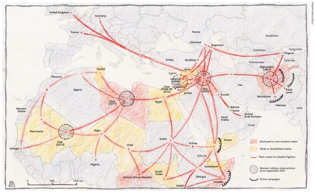
Graphic: Multiplying Paths of Jihad
Analysis, Citizen-Centered, Geospatial, Multinational Plus, Threats, Tribes
The truth at any cost lowers all other costs — curated by former US spy Robert David Steele.

Each map has an illustration of the map type, and additional links.
The Most Innovative Maps of 2013
1. The cloudless map.
2. The personalized map.
3. The real-time map.
4. The animated map.
5. The map that compares our present to the past.
6. The map that simulates the future.
7. The laser map.
8. The meta-map.
9. The 3D map.
10. The dot map of everyone.
Emily Badger is a staff writer at The Atlantic Cities. Her work has previously appeared in Pacific Standard, GOOD, The Christian Science Monitor, and The New York Times. She lives in Washington, D.C

Berto Jongman
Phi Beta Iota: An equivalent graphic focused on individual violence fostered by the 1% against the 99% (both physcial-economic and psych-social), would including the USA at an ORANGE level.
Note: Graphic does not properly show First Nation, including Greenland and larger than the USA, with roughly 300,000 inhabitants and in pole position (pun intented) to be the future core for humanity.
Tip of the Hat to SchwartzReport
UPDATED 19 FEB 14:
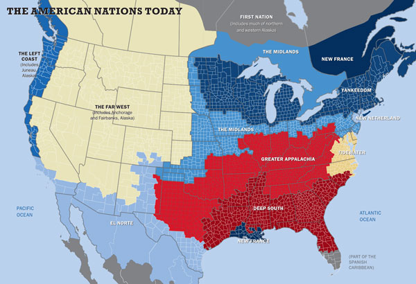
Review: American Nations – A History of the Eleven Rival Regional Cultures of North America
See Also:
2013 Healing the Americas with an Open Source Agency
Graphic: Robert Steele Global Strategy – The Hourglass Home Base Plus Four
SchwartzReport: South America Rising + New World Order II Meta-RECAP
Summary and RECAP Below the Line.
Continue reading “Graphic: USA — 11 Separate Nations Today + Americas RECAP + Book Review”

