LOOMIO is free and open-source software for anyone, anywhere, to participate in decisions that affect them.
“The world needs a better way to make decisions together. #Loomio is building it. You can help: http://thndr.it/1kaQhmy”
Click on Image to Enlarge
We’re a small team of open-source developers, facilitators and activists in New Zealand. On Tuesday March 11, we're crowdfunding to build a totally inclusive platform so anyone anywhere can participate in decisions that affect them. It's called Loomio 1.0.
I had the great pleasure of contributing a chapter to this new book recently published by Oxford University Press: Bits and Atoms: Information and Communication Technology in Areas of Limited Statehood. My chapter addresses the application of crisis mapping to areas of limited statehood, drawing both on theory and hands-on experience. The short introduction to my chapter is provided below to help promote and disseminate the book.
MuSIASEM is an open framework able to take into account the economic, environmental, social, cultural, technical and political dimensions in an integrated analysis, accounting for different flows such as monetary, energy, waste or water. As a result, ultimately we can get “congruent” relations among the different set of variables.
The results of the MuSIASEM are sets of georreferenced vectorial indicators that are easy to understand, and this is one of the strengths of the method. But it is build on strong and heavy theoretical blocks. Here we summarize its roots.
Complex System Theory
From CST, MuSIASEM has taken concepts that are useful to deal with the definition of the societies as part of a broader hierarchical system and with the different levels of it that are relevant for the analysis of the sustainability.
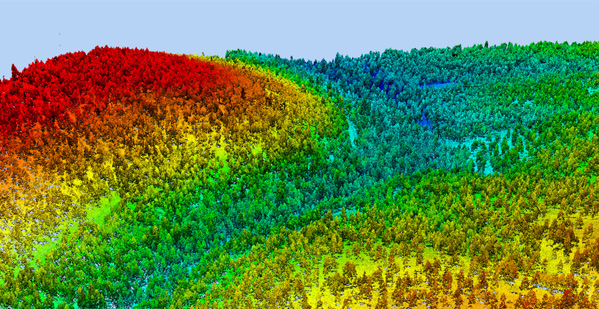
Hierarchical levels of a Socio-Ecosystem. By Cristina Madrid.
Under the CST perspective, the Societal Metabolism is a notion used to characterize the processes of energy and material transformation in a society that are necessary for its continued existence, sustainability or Autopoiesis. In order to maintain this, those transformations cannot overpass the thresholds posed by the Ecosystem Metabolism. Both, societies and ecosystems are levels of a Hierarchical System. In them, there are relations that have to be maintained within and among the levels, including the relations that control the biophysical transformations, or metabolic patterns. The metabolic patterns of the social level of a hierarchy depend on its internal and external relations. They pose internal and external constraints to the autopoesis of the system.
Bioeconomics
From Bioeconomics, MuSIASEM has used the flow-fund model of Georgescu-Roegen. With it, MuSIASEM is able to deal with the degrees of complexity given by the different meanings a resource has in each of the levels of analysis and by the relation between them.
In MuSIASEM, flow is a semantically open definition for elements that come into or out of the relevant system level during the analytical representation. They give information about what the system level(s) does to maintain itself. Fund is a definition used for those elements that remain there during the complete time of the representation. They are the components of the system that must be maintained.
I sometimes think I could drop all of my technical Twitter follows except for @kdnuggets and that would be more than enough to keep me busy. Today he mentioned MassBigData, a statewide initiative to open government data for exploitation. What used to happen inside 128 has spread as far west as Worcester.
. . . . . .
I’ve long advocated for expanding our national rail network and replacing the city networks, which once spanned the entire country from Long Island to Milwaukee. Here’s what the state of Massachusetts makes available in terms of transportation data as part of the initiative:
A little-known California company called Esri offers a “Facebook for Maps” that promises to change the way we interact with our environment, predict behavior, and make decisions in the decades ahead.
Click on Image to Enlarge
The setting is central California’s Yosemite National Park. A hiker, let’s call him Steve Clark, has gone missing on one of the trails. As the head park ranger, your job is to lead a search-and-rescue mission to find him. All you have to go on is the point where he was last seen, your training, and a computer; from this, you have to predict the behavior of a lost hiker. Sunset is approaching, and in some parts of the park the temperature will be below freezing in a matter of hours. What do you do?
Click on Image to Enlarge
Many experienced hikers know that the recommended course of action when lost is to follow a stream downhill and this will eventually lead to civilization. But you can’t assume that Steve Clark is aware of this, or that he’s even seen the Discovery Channel. He might elect to stay put, or, if he has a cell phone, he might be moving uphill to find a signal. You also don’t know if he’s injured. A person with a sprained ankle is less likely to walk up, but he may not move down, either.
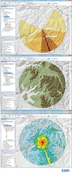
You go to your computer and open ArcGIS.com. A computer map of Yosemite that you’ve made and uploaded appears on the screen. Let’s say you also have access to a “big data” database of records from 30,000 lost hiker search-and-rescue missions and you can query this database with key words.
You soon learn that 66% of lost hikers are found within two miles of the spot last seen. You impose a ring over your map reflecting this two-mile perimeter. You then learn that 52% of lost hikers are found downhill, only 32% go up, and 16% keep walking at the same elevation. You impose an elevation layer on the area with all the land above the last point seen shaded one color and the land beneath it shaded another. You can even impose a new lens depicting tree and plant cover and open fields, and one depicting linear objects like trails, roads, power lines, and streams, knowing that the vast majority of lost hikers follow some sort of linear marker to avoid going in circles.
Phi Beta Iota: ESRI code is proprietary and they do not play well with others. They either have to change both of those conditions, or be replaced by CrisisMappers at scale. The future is open. This is not negotiable.