
PDF (15 Slides): MC&G Brief 2013
ROBERT STEELE: I led the charge on behalf of the U.S. Marine Corps (USMC) to add Mapping, Charting, & Geodesy (MC&G) to the Foreign Intelligence and Requirements Capabilities Plan (FIRCAP) in the early 1990's, back-stopped by US Special Forces Command (USSOCOM) where then J-2 Col Mike Pheneger had come to the same conclusion: it is irresponsible and utterly unprofessional for the US IC to be incapable of producing 1:50K combat charts (contour lines and cultural features) for the entire world. Turns out very little has changed, the National Geospatial Agency (NGA) is just as uncaring about the infantry and just as inept at global coverage as its predecessors.
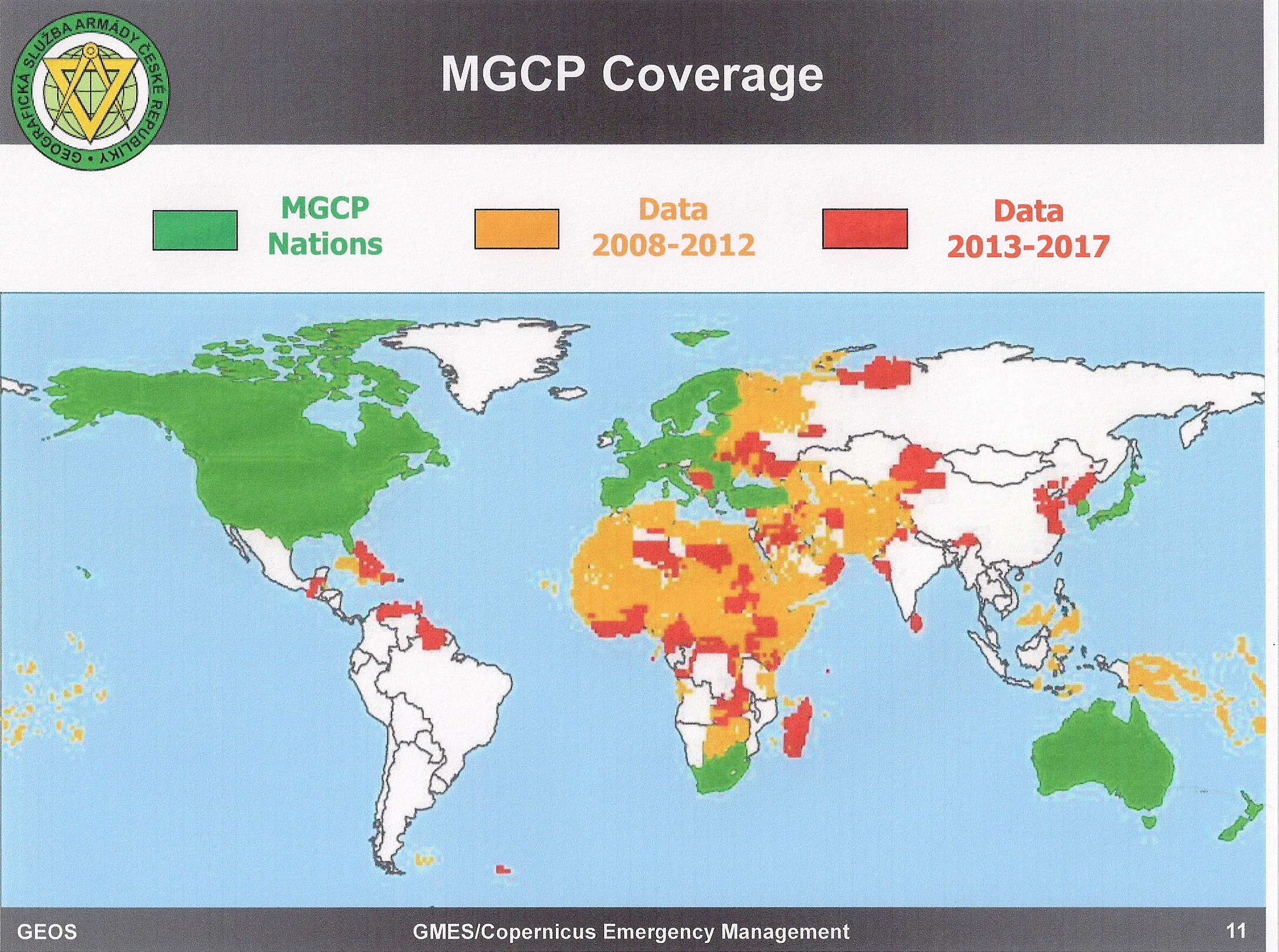
Furthermore, because of the dysfunctionality of the NGA approach to mapping, those in need are generally not properly informed of the ease with which one can obtain Russian military combat charts, if not at 1:50K then at 1:100K (which is what US forces in Somalia are using — Russian 1:100K), which can also be translated into English. Because of the “wars of national liberation” across the Southern Hemisphere, and their own natural interest in Central Asia, the Russians took this need seriously. NGA is even less likely to tell those in need that new maps can be created from existing imagery, as the Dutch did for the United Nations (UN) forces in the Congo, a need and a solution I helped orchestrate for LtGen Patrick Cammaert, NL RN, back in the day — it cost $3 million to address his basic needs, either using government capabilities as the Dutch did, or in the commercial marketplace, where only one company has my absolute respect, everyone else is posturing.
The overall MC&G situation is actually much worse than the above might suggest because of the false assumption by NGA that digital feeds and speeds would be provided — they are not — and that they could play catch up in extremis — they cannot. NGA and even DoD do not “get” that every battalion needs 175 copies of each map “on the shelf” because we should assume that our Global Positioning System (GPS) and related communications, computing, targeting, and information-sharing electromagnetic systems are one hostile laser away from being shut down.
USMC MC&G 1990 (2 Pages): MC&G Two Pages Original


