Patrick Meier: Using UAVs for Community Mapping & Disaster Risk Reduction — The Haiti Example

Crowd-Sourcing, Culture, Drones & UAVs, Geospatial, Governance
Patrick Meier
Patrick Meier

Using UAVs for Community Mapping and Disaster Risk Reduction in Haiti

“What if, to solve our problems, we simply need to rise above them?” CartONG and France’s OpenStreetMap (OSM) community recently teamed up to support OSM Haiti’s disaster risk reduction efforts by deploying a small UAV, “which proved very useful for participatory mapping.” The video documentary below provides an excellent summary of this humanitarian UAV mission which took place just a few weeks ago.

Click on Image to Enlarge

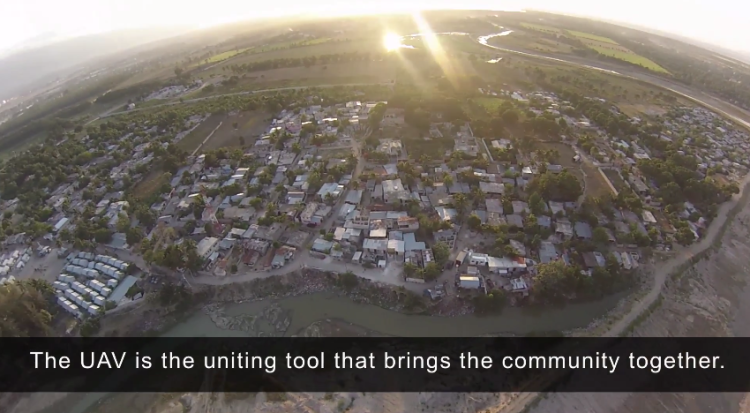
As I noted in this earlier blog post on grassroots UAVs, the use of UAVs at the community level can be viewed as an extension of community and participatory mapping, which is why community engagement is pivotal for humanitarian UAV deployments. In many ways, a micro-UAV can actually bring a community together; can catalyze conversations & participation, which should be taken as more than simply a positive externality. Public Participatory GIS Projects (PPGIS) have long been used as a means to catalyze community conversations and even conflict resolution and mediation. So one should not overlook the positive uses of UAVs as a way to convene a community. Indeed, as CartONG and partners rightly note in the above video documentary, “The UAV is the uniting tool that brings the community together.”

Read full post with additional graphics & photos.

Berto Jongman: 27 Maps Explaining Iraq Crisis

Geospatial
Berto Jongman
Berto Jongman

27 maps that explain the crisis in Iraq

by Zack Beauchamp, Max Fisher and Dylan Matthews on June 23, 2014

The current Iraq crisis began in early June, when the extremist group Islamic State of Iraq and the Levant (ISIS), which already controls parts of Syria, seized much of northern Iraq, including the major city of Mosul. The conflict has roots in Iraq's complicated history, its religious and ethnic divisions, and of course in the Iraq War that began with the 2003 US-led invasion. These 27 maps are a rough guide to today's crisis and the deeper forces behind it.

Continue reading “Berto Jongman: 27 Maps Explaining Iraq Crisis”

Patrick Meier: Zoomanitarians – Using Citizen Science and Next Generation Satellites to Accelerate Disaster Damage Assessments

Crowd-Sourcing, Data, Design, Geospatial, Governance, Resilience, Science
Patrick Meier
Patrick Meier

Zoomanitarians: Using Citizen Science and Next Generation Satellites to Accelerate Disaster Damage Assessments

Zoomanitarians has been in the works for well over a year, so we’re excited to be going fully public for the first time. Zoomanitarians is a joint initiative between Zooniverse (Brook Simmons), Planet Labs (Alex Bakir) and myself at QCRI. The purpose of Zoomanitarians is to accelerate disaster damage assessments by leveraging Planet Labs’ unique constellation of 28 satellites and Zooniverse’s highly scalable microtasking platform. As I noted in this earlier post, digital volunteers from Zooniverse tagged well over 2 million satellite images (of Mars, below) in just 48 hours. So why not invite Zooniverse volunteers to tag millions of images taken by Planet Labs after major disasters to help humanitarians accelerate their damage assessments?

Continue reading “Patrick Meier: Zoomanitarians – Using Citizen Science and Next Generation Satellites to Accelerate Disaster Damage Assessments”

Mini-Me: GoogleMaps Add Elevation — Good-Bye National Geospatial Agency? Can Tiling Extend to All-Source Data M4IS2/OSE?

Analysis, Earth Orientation, Geospatial, Geospatial
Who, Mini-Me?
Who, Mini-Me?

Huh?

Google Maps Now Show Elevation Statistics For Bikers

Google, the world's largest internet search operator, is bringing one of the most useful features to bikers using its Google Maps service. While cycling can be fun, sometimes an arbitrary hill climb can be a challenging task. But it appears that Google has finally come up with a fix for that, not essentially helping you get the bike to the top of the hill, but by showing an upcoming elevation in Google Maps' bike routes. The app now features elevation statistics to help bikers tackle steep hills.

Google did not officially announce the feature but confirmed to TechCrunch that the addition is indeed new to Maps. The Mountain View, California based tech giant has offered GPS functionality for bikers for few years now, but helped not more than being a map.

Click on Image to Enlarge

Bikers can simple select a bike route on the map and Google will find the directions for the destination. Following the update, information showing an elevation and descent will populate. In addition to the graphical representation of the hill, Google also displays a card to show the number of feet a biker must climb before reaching the top and descend through the other side.

Google will not display any elevation statistics when bikers are riding on flat roads. Google also confirmed to the tech blog that the new feature is available in all 14 countries where the biking directions are available on Maps, including Austria, Australia, Belgium, Canada, Switzerland, Germany, Denmark, Finland, Great Britain, Netherlands, Norway, New Zealand, Sweden and the US.

Google has been updating its mapping service quite frequently, of late. Earlier this month, the web giant added offline support for Google Maps, integrated Uber taxi service, improved local business search and more. These changes show how badly Google wants to stay ahead of its rivals, such as Nokia and Apple. The addition of more features to make the service useful for end users is surely an added advantage.

Continue reading “Mini-Me: GoogleMaps Add Elevation — Good-Bye National Geospatial Agency? Can Tiling Extend to All-Source Data M4IS2/OSE?”

Worth a Look: Whitebox Geospatial Analysis Tools — Open Source and Cross-Platform

Geospatial, IO Tools

Whitebox Geospatial Analysis Tools (GAT) is an open-source and cross-platform Geographic information system (GIS) and remote sensing software package that is distributed under the GNU General Public License. It has been developed by the members of the University of Guelph Centre for Hydrogeomatics and is intended for advanced geospatial analysis and data visualization in research and education settings. The package features a friendly graphical user interface (GUI) with help and documentation built into the dialog boxes for each of the more than 360 analysis tools. Users are also able to access extensive off-line and online help resources. The Whitebox GAT project started as a replacement for the Terrain Analysis System (TAS), a geospatial analysis software package written by John Lindsay. The current release support raster and vector (Shapefile) data structures.

Whitebox GAT is extendible. Users are able to create and add custom tools or plugins using any JVM language. The software also allows scripting using the Groovy, Python and JavaScript programming languages.

Whitebox Home Page

Patrick Meier: An Introduction to Humanitarian UAVs – Comment by Robert Steele

Access, Architecture, Data, Design, Geospatial, Resilience, SmartPlanet, Sources (Info/Intel)
Patrick Meier
Patrick Meier

An Introduction to Humanitarian UAVs and their Many Uses

Satellite images have been used to support humanitarian efforts for decades. Why? A bird’s eye view of a disaster-affected area simply captures far more information than most Earth-based data-collection technologies can. In short, birds have more situational awareness than we do. In contrast to satellites, UAVs offer significantly higher-resolution imagery, are unobstructed by clouds, can be captured more quickly, by more groups and more often at a fraction of the cost with far fewer licensing and data-sharing restrictions than satellite imagery.

Introduction to UAVs

There are basically three types of UAVs: 1) the balloon/kite variety; 2) fixed-wing UAVs; 3) rotary-wing UAVs. While my forthcoming book looks at humanitarian applications of each type, I’ll focus on fixed-wing and rotary-wing UAVs here since these are of greatest interest to humanitarian organizations. These types of UAVs differ from traditional remote control planes and helicopters because they are programmable and intelligent. UAVs can be programmed to take-off, fly and land completely autonomously, for example. They often include intelligent flight stabilization features that adapt for changing wind speeds and other weather-related conditions. They also have a number of built-in fail-safe mechanisms; some of the newer UAVs even include automated collision avoidance systems.

Click on Image to Enlarge

Fixed-wing UAVs like senseFly’s eBees (above) are launched by hand and can land a wide variety of surfaces, requiring only a few meters of landing space. They fly autonomously along pre-programmed routes and also land themselves auto-matically. My colleague Adam from senseFly recently flew eBees to support recovery efforts in the Philippines following Typhoon Yolanda. Adam is also on the Advisory Board of the Humanitarian UAV Network (UAViators). Other fixed-wing UAVs are flown manually and require an airstrip for both manual take-off and landing. Rotary-wing UAVs, in contrast, are “helicopters” with three or more propellors. Quadcopters, for example, have four propellors, like the Huginn X1 below, which my colleague Liam Dawson, another Advisory Board member, flew following Typhoon Yolanda in the Philippines. One advantage of rotary-UAVs is that they take-off and land vertically. They can also hover in one fixed place and can also be programmed to fly over designated points.

Click on Image to Enlarge

Rotary-UAVs cannot glide like their fixed-wing counterparts, which means their batteries get used up fairly quickly. So they can’t stay airborne for very long (~25 minutes, 2 kilometer range, depending on the model) compared to fixed-wing UAVs like the eBee (~45 minutes, 3 kilometers). Advisory Board member Shane Coughlan is designing fixed-wing humanitarian UAVs that will have a range of several hundred kilometers. Fixed-wing UAVs, however, cannot hover in one place over time. So both types of UAVs come with their advantages and disadvantages. Most UAV experts agree that fixed-wing and rotary-wing UAVs can serve complementary purposes, however. You can quickly use a quadcopter to an initial aerial recon and then send a fixed-wing UAV for more detailed, high-resolution imagery capture.

Humanitarian Uses of UAVs

Continue reading “Patrick Meier: An Introduction to Humanitarian UAVs – Comment by Robert Steele”

Jean Lievens: Open Source Urbanism & “Right to Infrastructure”

Access, Architecture, Crowd-Sourcing, Culture, Design, Geospatial, Governance, Innovation, Manufacturing, Materials, P2P / Panarchy, Politics, Resilience
Jean Lievens
Jean Lievens

The right to infrastructure: a prototype for open source urbanism

Alberto Corsín Jiménez

Abstract. This paper develops an analytical framework to place the rise of open source urbanism in context, and develops the concept of the ‘right to infrastructure’ as expressive of new ecologies of urban relations that have come into being. It describes, first, a genealogy for open source technology, focusing in particular on how open source urban hardware projects may challenge urban theory. It moves then to describe in detail various dimensions and implications of an open source infrastructural project in Madrid. In all, the paper analyses three challenges that the development of open source urban infrastructures is posing to the institutions of urban governance and property: the evolving shape and composition of urban ecologies; the technical and design challenges brought about by open source urban projects; and the social organisation of the ‘right to infrastructure’ as a political, active voice in urban governance. In the last instance, the right to infrastructure, I shall argue, signals the rise of the ‘prototype’ as an emerging figure for contemporary sociotechnical designs in and for social theory.
Keywords: open source urbanism, infrastructures, urban ecologies, urban commons, right to the city, prototypes

Corsín Jiménez A, 2014, “The right to infrastructure: a prototype for open source urbanism” Environment and Planning D: Society and Space 32(2) 342 – 362

PDF (21 Pages): 2014 Open Source Urbanism Right to Infrastructure