Graphic: Cahil-Keyes Multi-Scale Metamap Beta-2
Geospatial
The truth at any cost lowers all other costs — curated by former US spy Robert David Steele.
See Also:
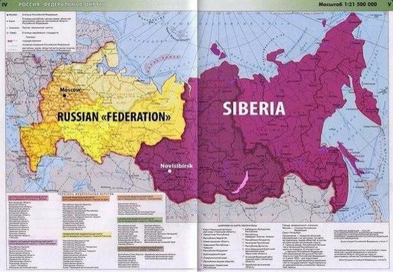
Moscow blocks Siberian message on one site only to have it appear on Euromaidan Press

Huh?
Google Maps Now Show Elevation Statistics For Bikers
Google, the world's largest internet search operator, is bringing one of the most useful features to bikers using its Google Maps service. While cycling can be fun, sometimes an arbitrary hill climb can be a challenging task. But it appears that Google has finally come up with a fix for that, not essentially helping you get the bike to the top of the hill, but by showing an upcoming elevation in Google Maps' bike routes. The app now features elevation statistics to help bikers tackle steep hills.
Google did not officially announce the feature but confirmed to TechCrunch that the addition is indeed new to Maps. The Mountain View, California based tech giant has offered GPS functionality for bikers for few years now, but helped not more than being a map.
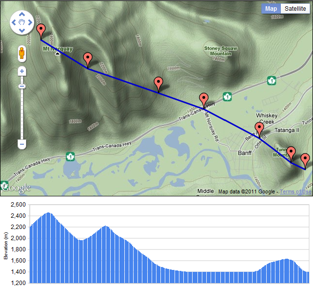
Bikers can simple select a bike route on the map and Google will find the directions for the destination. Following the update, information showing an elevation and descent will populate. In addition to the graphical representation of the hill, Google also displays a card to show the number of feet a biker must climb before reaching the top and descend through the other side.
Google will not display any elevation statistics when bikers are riding on flat roads. Google also confirmed to the tech blog that the new feature is available in all 14 countries where the biking directions are available on Maps, including Austria, Australia, Belgium, Canada, Switzerland, Germany, Denmark, Finland, Great Britain, Netherlands, Norway, New Zealand, Sweden and the US.
Google has been updating its mapping service quite frequently, of late. Earlier this month, the web giant added offline support for Google Maps, integrated Uber taxi service, improved local business search and more. These changes show how badly Google wants to stay ahead of its rivals, such as Nokia and Apple. The addition of more features to make the service useful for end users is surely an added advantage.


36 maps that will make you see the world in completely new ways
The internet has led to a renaissance in mapmaking, with thousands of interactive, illustrated, informational, or just plain silly maps being published on a daily basis. We’ve done a number of other pieces on some of the web’s interesting and weird maps, but there’s thousands more out there, and it can be hard to keep up. So here’s another installment, with 36 new maps we haven’t posted before.
Matt Hershberger
Matador, 14 April 2014
LIST:
1. Wind map of America
2. Actual discoveries by Europeans
3. Countries by racial tolerance
4. America’s favorite beers by state
5. Wind map of the world
6. North America’s pre-European languages
7. World consumption of milk
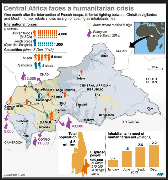
Updated Central African Republic Maps
The Central African Republic’s troubles were obvious to foreign policy watchers a year ago and now conflict has boiled over into outright ethnic cleansing. As a former French colony the best sources on this area are still in French and as a resource poor, land locked area there simply wasn’t much available in February of last year. Now that things have gotten really bad some new maps have emerged.
I would normally provide some sort of unifying commentary for a collection of maps. All I have to offer today is that someone commented on the lack of quality maps for the Central African Republic, and I decided to go digging.