“The righter we do the wrong thing, the wronger we become. When we make a mistake doing the wrong thing and correct it, we become wronger. When we make a mistake doing the right thing and correct it, we become righter. Therefore, it is better to do the right thing wrong than the wrong thing right. This is very significant because almost every problem confronting our society is a result of the fact that our public policy makers are doing the wrong things and are trying to do them righter.” (Ackoff 2004)
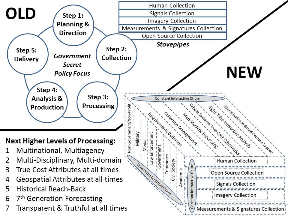
This is an updated variation of the chart first created for the Marine Corps Intelligence Center in 1990, as published in 1991 MCG Intelligence Support for Expeditionary Planners. This is a de facto top-level definition of a global intelligence cloud such as we should be building, perhaps in conjunction with NATO/PfP and the United Nations. Bearing in mind our view that all intelligence reform must be job and revenue neutral to assure Congressional support, this is how we would spend the money now being spent on the top secret cloud that will inevitably fail — Trailblazer on steroids, the ultimate crash and burn.
As is well known, “estimates of demographic flows are inexistent, outdated, or largely inconsistent, for most countries.” I would add costly to that list as well. So my QCRI colleague Ingmar Weber co-authored a very interesting study on the use of e-mail data to estimate international migration rates.
The study a large sample of Yahoo! emails sent by 43 million users between September 2009 and June 2011. “For each message, we know the date when it was sent and the geographic location from where it was sent. In addition, we could link the message with the person who sent it, and with the user’s demographic information (date of birth and gender), that was self reported when he or she signed up for a Yahoo! account. We estimated the geographic location from where each email message was sent using the IP address of the user.”
Click on Image to Enlarge
The authors used data on existing migration rates for a dozen countries and international statistics on Internet diffusion rates by age and gender in order to correct for selection bias. For example, “estimated number of migrants, by age group and gender, is multiplied by a correction factor to adjust for over-representation of more educated and mobile people in groups for which the Internet penetration is low.” The graphs below are estimates of age and gender-specific immigration rates for the Philippines. “The gray area represents the size of the bias correction.” This means that “without any correction for bias, the point estimates would be at the upper end of the gray area.” These methods “correct for the fact that the group of users in the sample, although very large, is not representative of the entire population.”
EDIT of 23 Oct 2012: Iran has direct access to the sea to its south and controls the Strait of Hormuz. It has a direct water connection to Russia via Eastern Europe. We would not be too hard on Mitt Romney, he is no more or less ignorant than Barack Obama talking about aircraft carriers and submarines. The fact is that both of these individuals mean well, but they are puppets in a theater, the outcome of the election is already known (Romney by 1%, thank you Karl Rove and Greg Palast), and we will have another four years of two-party tyranny and military-industrial complex serving the 1% and betraying the public interest. The third party candidates debating tonight are part of the problem–doing the wrong things righter instead of the right thing. The right thing is We the People Reform Coalition. Tell others, please.