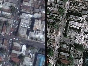
Google Maps updates with new Haiti pics: Hours-old satellite images show destruction
Google has released a new KML overlay — tech speak for map layer — that includes fresh images of Port-au-Prince.
According to GeoEye , the satellite imagery company that provided the photos, they were taken at 10:30 a.m. yesterday from a satellite 423 miles up.
By toggling the new image layer on and off, it’s easy to compare what the city looked like before the earthquake with the way it looks now.
Aside from the obvious destruction, one of the most striking features of the new images is the large number of presumably homeless people in the streets of the ruined neighborhoods.
Click here to see the new images in Google Maps.
Phi Beta Iota: Finally, but kudos never-the-less. This should always be the first thing done, perhaps with a global arrangement that has regional cost-sharing in place and can use military air breathers where commercial are not immediately available, but respecting Google's software and end-user delivery offering. There is still the matter of getting to shared Spacial Reference Systems (SRS). This could and should be used to “plot” Twitter messages that identify need, and in the back office, matching RapidSMS messages that can be aggregated to fund need resolution.
Where Are Haiti Earthquake Relief Funds Going?
Millions in donations have been raised since the earthquake in Haiti on Tuesday, but where is the money going?
Like Wyclef Jean's Yele Haiti which is urging people to text “Yele” to 501501 to donate $5 to the cause — which has raised more than $2 million so far — many other relief organizations have used mobile messaging to quickly gather funds.
Phi Beta Iota: What is most interesting about this is the fact that fund-raising (financial incentive for the organizers that take a 5% to 50% “cut) is very well developed and moving money, while the other end (requirements definition, logistics coordination, and “by household” delivery” is NOT developed at all. This is a good start toward the Global to Local Range of Needs Table, when that is developed, this will “flip” in that people will give for SPECIFIC itemized needs, not as a leap of faith in intermediaries that generally do NOT deliver full value.
What is LACKING is a single trusted Multinational Decision Support Center with both regional and global non-profit “cachet” as well as two-way reachback into all eight tribes of all nations, that can be the single point orchestrating the receipt and integration of all information in all languages in near-real-time, and the trusted point for validating both needs and the resolution of needs through the application of fundss.
See Also:
Graphic: Global Range of Nano-Needs
Graphic: Strategy for a Prosperous World at Peace
Worth a Look: Ushandi Open Source Crowd-Sourcing
2009 Briefing: Open Everything at UNICEF in NYC
Review: GIS for Decision Support and Public Policy Making
Memoranda: Policy-Budget Outreach Tool
Worth a Look: Free Currencies Flow Project Now Open
Search: Seven Tribes (now Eight Tribes)
Journal: Yemen Maps and Prospects
Reference: NGO Guide for the Military


