Architects in Amsterdam have started building what they say is one of the world's first full-sized 3D-printed houses. The structure is being built using a plastic heavily based on plant oil. The team behind the house claim it is a waste-free, eco-friendly way to design and construct the cities of the future.
Whitebox Geospatial Analysis Tools (GAT) is an open-source and cross-platform Geographic information system (GIS) and remote sensing software package that is distributed under the GNU General Public License. It has been developed by the members of the University of GuelphCentre for Hydrogeomatics and is intended for advanced geospatial analysis and data visualization in research and education settings. The package features a friendly graphical user interface (GUI) with help and documentation built into the dialog boxes for each of the more than 360 analysis tools. Users are also able to access extensive off-line and online help resources. The Whitebox GAT project started as a replacement for the Terrain Analysis System (TAS), a geospatial analysis software package written by John Lindsay. The current release support raster and vector (Shapefile) data structures.
Whitebox GAT is extendible. Users are able to create and add custom tools or plugins using any JVM language. The software also allows scripting using the Groovy, Python and JavaScript programming languages.
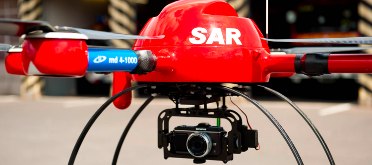
Satellite images have been used to support humanitarian efforts for decades. Why? A bird’s eye view of a disaster-affected area simply captures far more information than most Earth-based data-collection technologies can. In short, birds have more situational awareness than we do. In contrast to satellites, UAVs offer significantly higher-resolution imagery, are unobstructed by clouds, can be captured more quickly, by more groups and more often at a fraction of the cost with far fewer licensing and data-sharing restrictions than satellite imagery.
Introduction to UAVs
There are basically three types of UAVs: 1) the balloon/kite variety; 2) fixed-wing UAVs; 3) rotary-wing UAVs. While my forthcoming book looks at humanitarian applications of each type, I’ll focus on fixed-wing and rotary-wing UAVs here since these are of greatest interest to humanitarian organizations. These types of UAVs differ from traditional remote control planes and helicopters because they are programmable and intelligent. UAVs can be programmed to take-off, fly and land completely autonomously, for example. They often include intelligent flight stabilization features that adapt for changing wind speeds and other weather-related conditions. They also have a number of built-in fail-safe mechanisms; some of the newer UAVs even include automated collision avoidance systems.
Click on Image to Enlarge
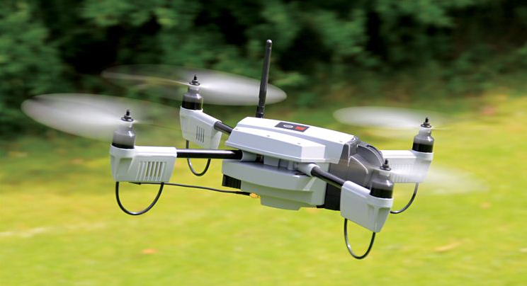
Fixed-wing UAVs like senseFly’s eBees (above) are launched by hand and can land a wide variety of surfaces, requiring only a few meters of landing space. They fly autonomously along pre-programmed routes and also land themselves auto-matically. My colleague Adam from senseFly recently flew eBees to support recovery efforts in the Philippines following Typhoon Yolanda. Adam is also on the Advisory Board of the Humanitarian UAV Network (UAViators). Other fixed-wing UAVs are flown manually and require an airstrip for both manual take-off and landing. Rotary-wing UAVs, in contrast, are “helicopters” with three or more propellors. Quadcopters, for example, have four propellors, like the Huginn X1 below, which my colleague Liam Dawson, another Advisory Board member, flew following Typhoon Yolanda in the Philippines. One advantage of rotary-UAVs is that they take-off and land vertically. They can also hover in one fixed place and can also be programmed to fly over designated points.
Click on Image to Enlarge
Rotary-UAVs cannot glide like their fixed-wing counterparts, which means their batteries get used up fairly quickly. So they can’t stay airborne for very long (~25 minutes, 2 kilometer range, depending on the model) compared to fixed-wing UAVs like the eBee (~45 minutes, 3 kilometers). Advisory Board member Shane Coughlan is designing fixed-wing humanitarian UAVs that will have a range of several hundred kilometers. Fixed-wing UAVs, however, cannot hover in one place over time. So both types of UAVs come with their advantages and disadvantages. Most UAV experts agree that fixed-wing and rotary-wing UAVs can serve complementary purposes, however. You can quickly use a quadcopter to an initial aerial recon and then send a fixed-wing UAV for more detailed, high-resolution imagery capture.
HELSINKI, Finland — If there's something you'd like to know about Helsinki, someone in the city administration most likely has the answer. For more than a century, this city has funded its own statistics bureaus to keep data on the population, businesses, building permits, and most other things you can think of. Today, that information is stored and freely available on the internet by an appropriately named agency, City of Helsinki Urban Facts.
There's a potential problem, though. Helsinki may be Finland's capital and largest city, with 620,000 people. But it’s only one of more than a dozen municipalities in a metropolitan area of almost 1.5 million. So in terms of urban data, if you're only looking at Helsinki, you’re missing out on more than half of the picture.
Helsinki and three of its neighboring cities are now banding together to solve that problem. Through an entity called Helsinki Region Infoshare, they are bringing together their data so that a fuller picture of the metro area can come into view.
That’s not all. At the same time these datasets are going regional, they're also going “open.” Helsinki Region Infoshare publishes all of its data in formats that make it easy for software developers, researchers, journalists and others to analyze, combine or turn into web-based or mobile applications that citizens may find useful. In four years of operation, the project has produced more than 1,000 “machine-readable” data sources such as a map of traffic noise levels, real-time locations of snow plows, and a database of corporate taxes.
A global leader
All of this has put the Helsinki region at the forefront of the open-data movement that is sweeping cities across much of the world. The concept is that all kinds of good things can come from assembling city data, standardizing it and publishing it for free. Last month, Helsinki Region Infoshare was presented with the European Commission's prize for innovation in public administration.
This is one of those fun things that as a geek mom, I had to share. I also think it's a cool project to do if you have the parts. This is the sort of thing I would've loved to have done as a kid. (I do want to get my hands on a Raspberry Pi at some point!) Watch the video in the article. It's not practical, but it's still pretty cool.
When the Raspberry Pi Compute Module was announced ealier this month, a group of us at MAKE discussed what kind of impact it could have. For one, we thought perhaps it could help foster the rise of DIY electronics such as cameras, cellphones, and laptops.
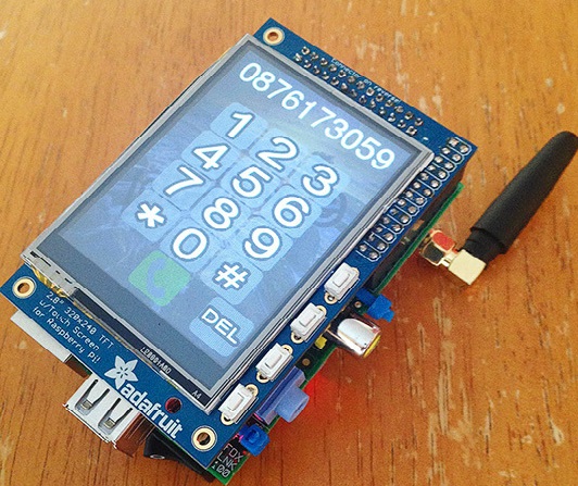
Even without the Compute Module, software engineer and Raspberry Pi enthusiast Dave Hunt made a lot of headway with his own Raspberry Pi-based cellphone. By sandwiching together a Raspberry Pi Model B, TFT touch screen, a lithium polymer battery, and GSM module, Dave has cobbled together a portable GSM phone that can place calls with a headset.
“It’s more of a proof of concept to see what could be done with a relatively small form factor with off-the-shelf (cheap) components,” Dave says. “I don’t expect everyone to be rushing out to build this one, but I had great fun in doing it, as it builds quite nicely on my previous projects.” The total cost of the PiPhone project? Just $158, no contract required! See it in action below:
The Humanitarian UAV Network (UAViators) has taken off much faster than I expected. More than 240 members in 32 countries have joined the network since it’s launch just a few weeks ago.
I was also pleasantly surprised by the number of humanitarian organizations that got in touch with me right after the launch. Many of them are just starting to explore this space. And I found it refreshing that every single one of them considers the case for humanitarian UAVs to be perfectly obvious. Almost all of the groups also mentioned how they would have made use of UAVs in recent disasters. Some are even taking steps now to set up rapid-response UAV teams.
Click on Image to Enlarge
My number one priority after launching the network was to start working on a Code of Conduct to guide the use of UAVs in humanitarian settings—the only one of it’s kind as far as I know. While I had initially sought to turn this Code of Conduct into a check-list, it became clear from the excellent feedback provided by members and the Advisory Board that we needed two separate documents. So my RA’s and I have created a more general Code of Conduct along with a more detailed operational check-list for flying UAVs in humanitarian settings. You’ll find the check-list here. Big thanks to Advisory Board member Gene Robinson for letting me draw on his excellent book for this check-list. Both the Code of Conduct and Check-List will continue to be updated on a monthly basis, so please do chime in and help us improve them.
Enterprise software vendor TIBCO has acquired Jaspersoft, an open source business intelligence company, for approximately $185 million. It’s not an earth-shaking deal, but it could be a sign of things to come in an analytics software market full of companies and products that have a hard time standing out from the crowd.
MBAs will drooling at the thought of business intelligence deal making if the article’s premise is correct.
But there are several other angles in this Tibco Jaspersoft tie up.