“Open Access Antiquarianism is the collective madcap efforts of an archaeologist, a computer scientist, and a structural engineer to push the boundaries of what is possible in the interface between technology and cultural heritage, art and diagnostics.
Excerpts from Stephen Wilson’s Information Arts: Intersections of Art, Science, and Technology that aptly illustrate why Open Access Antiquarianism is seeking to blend our study of technology and archaeology with art:
Since 1993 we’ve been experimenting with a strategy for convening this kind of large-‐system conversation and we are excited at how well our approach is working, and the prospect for how it can work at the national and global levels. Our approach is different than the one described in the Project paper, however. And it’s different from “Deliberative Democracy” approaches in general because it aims for a creative conversation, rather than one that is deliberative. This requires a different set of facilitation skills and understandings about group process.
Satellite images have been used to support humanitarian efforts for decades. Why? A bird’s eye view of a disaster-affected area simply captures far more information than most Earth-based data-collection technologies can. In short, birds have more situational awareness than we do. In contrast to satellites, UAVs offer significantly higher-resolution imagery, are unobstructed by clouds, can be captured more quickly, by more groups and more often at a fraction of the cost with far fewer licensing and data-sharing restrictions than satellite imagery.
Introduction to UAVs
There are basically three types of UAVs: 1) the balloon/kite variety; 2) fixed-wing UAVs; 3) rotary-wing UAVs. While my forthcoming book looks at humanitarian applications of each type, I’ll focus on fixed-wing and rotary-wing UAVs here since these are of greatest interest to humanitarian organizations. These types of UAVs differ from traditional remote control planes and helicopters because they are programmable and intelligent. UAVs can be programmed to take-off, fly and land completely autonomously, for example. They often include intelligent flight stabilization features that adapt for changing wind speeds and other weather-related conditions. They also have a number of built-in fail-safe mechanisms; some of the newer UAVs even include automated collision avoidance systems.
Click on Image to Enlarge
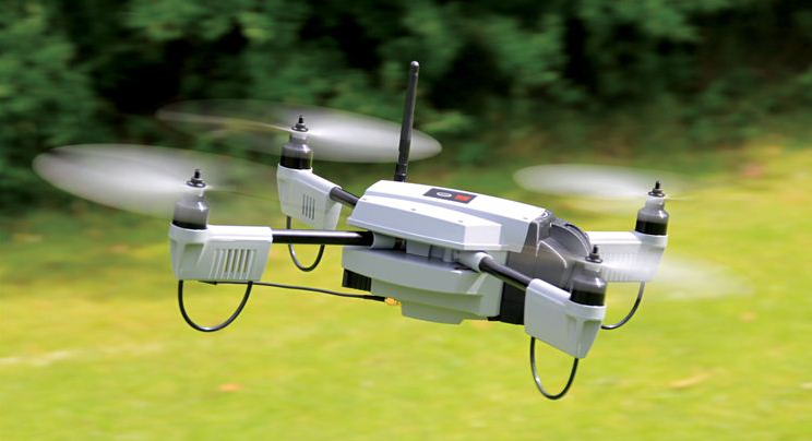
Fixed-wing UAVs like senseFly’s eBees (above) are launched by hand and can land a wide variety of surfaces, requiring only a few meters of landing space. They fly autonomously along pre-programmed routes and also land themselves auto-matically. My colleague Adam from senseFly recently flew eBees to support recovery efforts in the Philippines following Typhoon Yolanda. Adam is also on the Advisory Board of the Humanitarian UAV Network (UAViators). Other fixed-wing UAVs are flown manually and require an airstrip for both manual take-off and landing. Rotary-wing UAVs, in contrast, are “helicopters” with three or more propellors. Quadcopters, for example, have four propellors, like the Huginn X1 below, which my colleague Liam Dawson, another Advisory Board member, flew following Typhoon Yolanda in the Philippines. One advantage of rotary-UAVs is that they take-off and land vertically. They can also hover in one fixed place and can also be programmed to fly over designated points.
Click on Image to Enlarge
Rotary-UAVs cannot glide like their fixed-wing counterparts, which means their batteries get used up fairly quickly. So they can’t stay airborne for very long (~25 minutes, 2 kilometer range, depending on the model) compared to fixed-wing UAVs like the eBee (~45 minutes, 3 kilometers). Advisory Board member Shane Coughlan is designing fixed-wing humanitarian UAVs that will have a range of several hundred kilometers. Fixed-wing UAVs, however, cannot hover in one place over time. So both types of UAVs come with their advantages and disadvantages. Most UAV experts agree that fixed-wing and rotary-wing UAVs can serve complementary purposes, however. You can quickly use a quadcopter to an initial aerial recon and then send a fixed-wing UAV for more detailed, high-resolution imagery capture.
The Humanitarian UAV Network (UAViators) has taken off much faster than I expected. More than 240 members in 32 countries have joined the network since it’s launch just a few weeks ago.
I was also pleasantly surprised by the number of humanitarian organizations that got in touch with me right after the launch. Many of them are just starting to explore this space. And I found it refreshing that every single one of them considers the case for humanitarian UAVs to be perfectly obvious. Almost all of the groups also mentioned how they would have made use of UAVs in recent disasters. Some are even taking steps now to set up rapid-response UAV teams.
Click on Image to Enlarge
My number one priority after launching the network was to start working on a Code of Conduct to guide the use of UAVs in humanitarian settings—the only one of it’s kind as far as I know. While I had initially sought to turn this Code of Conduct into a check-list, it became clear from the excellent feedback provided by members and the Advisory Board that we needed two separate documents. So my RA’s and I have created a more general Code of Conduct along with a more detailed operational check-list for flying UAVs in humanitarian settings. You’ll find the check-list here. Big thanks to Advisory Board member Gene Robinson for letting me draw on his excellent book for this check-list. Both the Code of Conduct and Check-List will continue to be updated on a monthly basis, so please do chime in and help us improve them.
Using Social Media to Predict Economic Activity in Cities
Economic indicators in most developing countries are often outdated. A new study suggests that social media may provide useful economic signals when traditional economic data is unavailable. In “Taking Brazil’s Pulse: Tracking Growing Urban Economies from Online Attention” (PDF), the authors accurately predict the GDPs of 45 Brazilian cities by analyzing data from a popular micro-blogging platform (Yahoo Meme). To make these predictions, the authors used the concept of glocality, which notes that “economically successful cities tend to be involved in interactions that are both local and global at the same time.” The results of the study reveals that “a city’s glocality, measured with social media data, effectively signals the city’s economic well-being.”
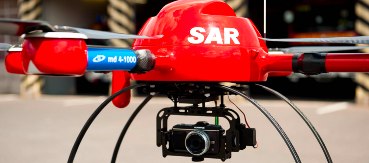
My brother recently pointed me to this BBC News article on the use of drones for Search & Rescue missions in England’s Lake District, one of my favorite areas of the UK. The picture below is one I took during my most recent visit. In my earlier blog post on the use of UAVs for Search & Rescue operations, I noted that UAV imagery & video footage could be quickly analyzed using a microtasking platform (like MicroMappers, which we used following Typhoon Yolanda). As it turns out, an enterprising team at the University of Central Lancashire has been using microtasking as part of their UAV Search & Rescue exercises in the Lake District.
Click on Image to Enlarge
Every year, the Patterdale Mountain Rescue Team assists hundreds of injured and missing persons in the North of the Lake District. “The average search takes several hours and can require a large team of volunteers to set out in often poor weather conditions.” So the University of Central Lancashire teamed up with the Mountain Rescue Team to demonstrate that UAV technology coupled with crowdsourcing can reduce the time it takes to locate and rescue individuals.