DefDog: CIA offers detailed account of attack in Libya

DoD, Government
0Shares
DefDog

CIA rushed to save diplomats as Libya attack was underway

Greg Miller

Washington Post, 1 November 2012

The CIA rushed security operatives to an American diplomatic compound in Libya within 25 minutes after it had come under attack and played a more central role in the effort to fend off a night-long siege than has been publicly acknowledged, U.S. intelligence officials said Thursday.

The agency mobilized the evacuation effort, took control of an unarmed U.S. military drone to map possible escape routes, dispatched an emergency security team from Tripoli, the capital, and chartered aircraft that ultimately carried surviving U.S. personnel to safety on Sept. 12, U.S. officials said.

. . . . . . .

Instead, U.S. intelligence officials insisted that CIA operatives in Benghazi and Tripoli made decisions rapidly throughout the assault with no interference from Washington, even while acknowledging that CIA security forces were badly outmatched and largely unable to mobilize Libyan security teams until it was too late.

Among the new disclosures is that the CIA station chief in Tripoli sent an emergency security force, with about a half-dozen agency operatives as well as two U.S. military personnel, to Benghazi aboard a hastily chartered aircraft while the attack was underway.

Read full article.

Continue reading “DefDog: CIA offers detailed account of attack in Libya”

Winslow Wheeler: Romney’s Unrealistic Defense Budget with Comment by Robert Steele

Ethics, Military
0Shares
Winslow Wheeler

Romney's defense budget is unrealistic

By Winslow T. Wheeler, director, Straus Military Reform Project at the Project On Government Oversight – 11/01/12 10:45 AM ET

Mitt Romney's proposal to boost defense spending until it reaches “a floor of four percent of GDP [gross domestic product],” as he proclaims at his official website, is an insult to history.

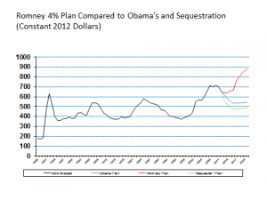
This graph [below] shows how unprecedented it is. It tracks spending for the Department of Defense (DOD) from 1948 to 2022, expressed in inflation-adjusted dollars normalized to 2012. The data up to 2012 are actual spending. The data for the years after 2012 show Romney's plan (in red), President Obama's (in blue), and the spending to be imposed by sequestration (in green) – the result of the Budget Control Act's automatic reductions now scheduled for January 2, 2013.

Click on Image to Enlarge

The Romney Plan shown assumes a gradual build up to his four percent goal, as calculated by Travis Sharp at the Center for a New American Security. Compared to other calculations of Romney’s declared intent, it is one of the more modest. The data for the Obama plan are from his 2013 budget, and the data for sequestration is from the Congressional Budget Office. In each, money has been included to accommodate a rapid drawdown from Afghanistan: all three data lines assume the Obama budget for overseas contingencies in 2013, $88.5 billion; an arbitrary assumption of $50 billion for 2014, $25 billion for 2015, and nothing after that.  In other words, the spending levels shown are about as low as one might conceive.

Romney’s plan would boost the Pentagon’s budget more or less $300 billion above the previous post-World War Two highs, namely the Korea and Vietnam wars and the Reagan Cold War peak, and it would more than double the average amount of DOD spending during the Cold War: $440 billion compared to $900 billion.

Continue reading “Winslow Wheeler: Romney's Unrealistic Defense Budget with Comment by Robert Steele”

9 Nov 2010 Washington DC Borders and the Internet A workshop on social media, surveillance, and knowledge production

Advanced Cyber/IO
0Shares

Borders and the Internet

A workshop on social media, surveillance, and knowledge production

Despite the promises and growth of digital social networks and the Web, social tensions and boundaries pervade our everyday “virtual” communications, shaped by a number of cultural, national and structural borders.  Come help us explore the current (r)evolutions of the global Internet.

featuring

Francesca Musiani
Yahoo! Fellow, Institute for the Study of Diplomacy, Georgetown University
“The plurality of Internet borders”

Seeta Peña Gangadharan
Senior Research Fellow, Open Technology Initiative, New America Foundation
“Internet borders and rights: Vulnerable populations, digital inclusion, and its dark sides”

David Ribes
Assistant Professor, Communication, Culture and Technology Program (CCT), Georgetown University
“Internet borders: Orphans of infrastructure?”

Friday, November 9, 2012
12:00 PM – 2:00 PM
Mortara Center for International Studies
3600 N Street, NW

A light lunch will be served.

For more information on the Institute for the Study of Diplomacy, please visit our website.

GI Wilson: American Thinker on US Arms Smuggling into Syria as Root of Benghazi Attack + Libya / Syria / Video Meta-RECAP

Corruption, Government, Ineptitude
0Shares
GI Wilson, USMC (Ret)

Benghazi Reveals Obama-Islamist Alliance

By James Lewis

American Thinker, November 1, 2012

The nature of the Benghazi disaster is now clear.  Ambassador Stevens was engaged in smuggling sizable quantities of Libyan arms from the destroyed Gaddafi regime to the Syrian rebels, to help overthrow the Assad regime in Syria.  Smuggling arms to the so-called “Free Syrian Army” is itself a huge gamble, but Obama has been a gambler with human lives over the last four years, as shown by the tens of thousands of Arabs who have died in the so-called Arab Spring — which has brought nothing but disaster to the Arab world.

For the last four years, the Obama policy has been to offer aid and comfort violent Islamic radicals in the delusional belief that their loyalty can be bought.  We therefore betrayed Hosni Mubarak, our 30-year ally in Egypt, so that the Muslim Brotherhood led by Muhammed Morsi could take over.  Obama indeed demanded publicly that Mubarak resign, for reasons that never made any sense at all.  Egypt went into a political and economic tailspin, and the Muslim Brotherhood were elected.  The Muslim radicals have now purged the only other viable political force, the army and police, to protect their monopoly on power.  We have colluded in that betrayal.

Continue reading “GI Wilson: American Thinker on US Arms Smuggling into Syria as Root of Benghazi Attack + Libya / Syria / Video Meta-RECAP”

Patrick Meier: Crowdsourcing the Evaluation of Post-Sandy Building Damage Using Aerial Imagery

Geospatial
0Shares
Patrick Meier

Crowdsourcing the Evaluation of Post-Sandy Building Damage Using Aerial Imagery

My colleague Schuyler Erle from Humanitarian OpenStreetMap  just launched a very interesting effort in response to Hurricane Sandy. He shared the info below via CrisisMappers earlier this morning, which I’m turning into this blog post to help him  recruit more volunteers.

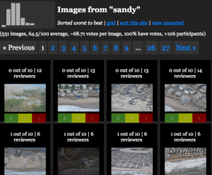
Schuyler and team just got their hands on the Civil Air Patrol’s (CAP) super high resolution aerial imagery of the disaster affected areas. They’ve imported this imagery into their Micro-Tasking Server MapMill created by Jeff Warren and are now asking volunteers to help tag the images in terms of the damage depicted in each photo. “The 531 images on the site were taken from the air by CAP over New York, New Jersey, Rhode Island, and Massachusetts on 31 Oct 2012.”

Click on Image to Enlarge

To access this platform, simply click here: http://sandy.hotosm.org.

Click on Image to Enlarge

“For each photo shown, please select ‘ok’ if no building or infrastructure damage is evident; please select ‘not ok’ if some damage or flooding is evident; and please select ‘bad’ if buildings etc. seem to be significantly damaged or underwater. Our *hope* is that the aggregation of the ok/not ok/bad ratings can be used to help guide FEMA resource deployment, or so was indicated might be the case during RELIEF at Camp Roberts this summer.”

A disaster response professional working in the affected areas for FEMA replied (via CrisisMappers) to Schuyler’s efforts to confirm that:

Continue reading “Patrick Meier: Crowdsourcing the Evaluation of Post-Sandy Building Damage Using Aerial Imagery”

SmartPlanet: Smart Interactive Paint on Dutch Highways

Advanced Cyber/IO
0Shares

Smart paint lights your way on the highway

By mid-2013, the Netherlands will feature glow-in-the-dark tarmac and dynamic paint that warns drivers of weather conditions.

Click on Image to Enlarge

“The Smart Highway” is a concept designed by Studio Roosegaarde and Heijmans Infrastructure. Including glow-in-the-dark roads, interactive lighting and an induction priority lane for electric vehicles, the team wants to use light, energy and road signs that automatically adapt to varying traffic conditions.

One particularly interesting feature is the luminous pathways in the road. Treated with a foto-luminizing powder, extra lighting in the dark becomes “unnecessary”, according to Studio Roosegaarde. Charging by solar technology in the day, once daylight has fled, the pathways then illuminate the contours of the road for up to ten hours.

In addition, ‘dynamic paint’ responds to changes in temperature, and then can relay traffic information to drivers. For example, if its -5C and slippery, the roads are highlighted with ice crystals.

“Research on smart transportation systems and smart roads has existed for over 30 years — call any transportation and infrastructure specialist and you’ll find out yourself,” Studio Roosegaarde communications partner Emina Sendijarevic told Wired.co.uk. “What’s lacking is the implementation of those innovations and making those innovations intuitive and valuable to the end-consumers — drivers. For this, a mentality change needs to take place within a country and its people.”

Awarded with a Best Future Concept by the Dutch Design Awards 2012, the smart highways will be in use next year.

Image credit: Studio Roosegaarde

GI Wilson: Maps for Post-Sandy Recovery – Good, Bad, & Ugly – Comment by Robert Steele

Earth Intelligence, Geospatial, IO Mapping
0Shares
Col GI Wilson, USMC (Ret)

We always have a map problem…I know you have known this for yrs and yrs and been the single voice in the map wilderness calling out….I wonder who got all those old Soviet maps after the fall…..we have never solved this problem…we just think we have. yes…No…?

After Sandy, Intelligence Agencies Scramble To Feed Maps, Data To Rescuers

Colin Clark

AOL Government, 30 October 2012

Click on Image to Enlarge

As FEMA, firemen, police and the National Guard wade into the devastation visited upon us by Hurricane Sandy, many of them are using maps and other information made available to them by intelligence agencies.

While intelligence analysts and their technical specialists usually spend their time targeting bad guys and helping troops plan to get them, some of them have gotten the rare and welcome chance to help their own countrymen at home several times since Hurricane Katrina ravaged New Orleans.

The National Geospatial Intelligence Agency provides most of the support to civil authorities during disasters. It takes photos, infrared and other data from satellites and airplanes and builds them into remarkably detailed and accurate maps.

Read full article.

Continue reading “GI Wilson: Maps for Post-Sandy Recovery – Good, Bad, & Ugly – Comment by Robert Steele”