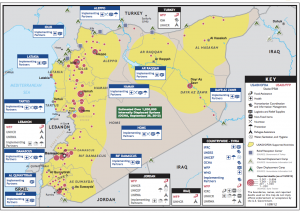
Why USAID’s Crisis Map of Syria is so Unique
While static, this crisis map includes a truly unique detail. Click on the map below to see a larger version as this may help you spot what is so striking.
For a hint, click this link. Still stumped? Look at the sources listed in the Key.
ANSWER from Patrick Meier: AID map uses Syria Tracker as a source for Reported Deaths.
Previously posted:
Patrick Meier: Crisis Mapping Syria – Automated Data Mining and Crowdsourced Human Intelligence


