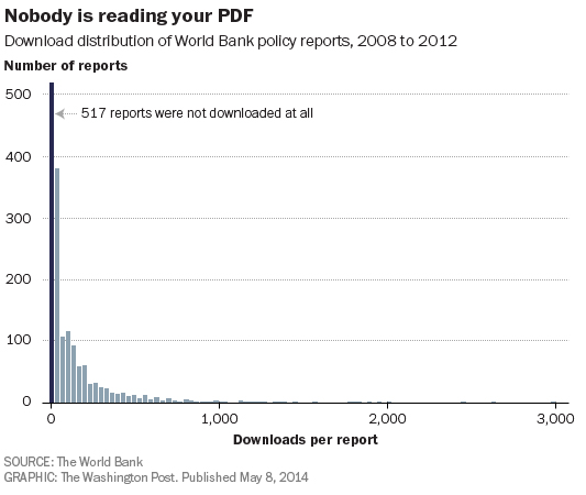
What if someone had already figured out the answers to the world's most pressing policy problems, but those solutions were buried deep in a PDF, somewhere nobody will ever read them?
Click on Image to Enlarge
According to a recent report by the World Bank, that scenario is not so far-fetched. The bank is one of those high-minded organizations — Washington is full of them — that release hundreds, maybe thousands, of reports a year on policy issues big and small. Many of these reports are long and highly technical, and just about all of them get released to the world as a PDF report posted to the organization's Web site.
The World Bank recently decided to ask an important question: Is anyone actually reading these things? They dug into their Web site traffic data and came to the following conclusions: Nearly one-third of their PDF reports had never been downloaded, not even once. Another 40 percent of their reports had been downloaded fewer than 100 times. Only 13 percent had seen more than 250 downloads in their lifetimes. Since most World Bank reports have a stated objective of informing public debate or government policy, this seems like a pretty lousy track record.
After reading an article called “How Google Earth Works” on the great site HowStuffWorks.com, it became apparent that the article was more of a “how cool it is” and “here’s how to use it” than a “how Google Earth [really] works.”
So I thought there might be some interest, and despite some valid intellectual property concerns, here we are, explaining how at least part of Google Earth works.
Keep in mind, those IP issues are real. Keyhole (now known as Google Earth) was attacked once already with claims that they copied someone else’s inferior (IMO) technology. The suit was completely dismissed by a judge, but only after many years of pain. Still, it highlights one problem of even talking about this stuff. Anything one says could be fodder for some troll to claim heinvented what you did because it “sounds similar.” The judge in the Skyline v. Google case understood that “sounding similar” is not enough to prove infringement. Not all judges do.
Anyway, the solution to discussing “How Google Earth [Really] Works” is to stick to information that has already been disclosed in various forms, especially in Google’s own patents, of which there are relatively few. Fewer software patents is better for the world. But in this case, more patents would mean we could talk more openly about the technology, which, btw, was one of the original goals of patents — a trade of limited monopoly rights in exchange for a real public benefit: disclosure. But I digress…
For the more technically inclined, you may want to read these patents directly. Be warned: lawyers and technologists sometimes emulsify to form a sort of linguistic mayonnaise, a soul-deadening substance known as Patent English, or Painglish for short . If you’re brave, or masochistic, here you go:
There are also a few more loosely related Google patents. I don’t know why these are shouting, but perhaps because they’re very important to the field. I’ll hopefully get to these in more detail in future articles:
And there is this more informative technical paper from SGI (PDF) on hardware “clipmapping,” which we’ll refer to later on. Michael Jones, btw, is one of the driving forces behind Google Earth, and as CTO, is still advancing the technology.
I’m going to stick closely to what’s been disclosed or is otherwise common technical knowledge. But I will hopefully explain it in a way that most humans can understand and maybe even appreciate. At least that’s my goal. You can let me know.
Big Caveat: the Google Earth code base has probably been rewritten several times since I was involved with Keyhole and perhaps even after these patents were submitted. Suffice it to say, the latest implementations may have changed significantly. And even my explanations are going to be so broad (and potentially out-dated) that no one should use this article as the basis for anything except intellectual curiosity and understanding.
Also note: we’re going to proceed in reverse, strange as it may seem, from the instant the 3D Earth is drawn on your screen, and later trace back to the time the data is served. I believe this will help explain why things are done as they are and why some other approaches don’t work nearly as well.
Late last week ESRI announced that its ArcGIS Online services will be migrating to the Mercator-based tiling scheme used by Google Maps and Bing Maps by the end of the year. Previously these services have used the WGS 1984 geographic coordinate system with a 512 x 512 pixel size. Google Maps and Bing use a modified Mercator projection with a 256 x 256 tiles size. The differences between ArcGIS Online and the popular Google Maps and Bing tiling schemes caused problems for many organizations. According to ESRI,
Some organizations struggle with choosing either the ArcGIS Online tiling scheme to match their ESRI software stack, or the Google / Bing tiling scheme to match a better-known standard. With a unified tiling scheme for the three services, the decision gets a lot easier.
The post goes on to discuss the advantages and challenges of switching to the new tiling scheme and also discusses a workflow for caching your maps in the new scheme.
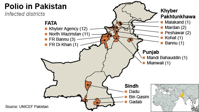
Pakistan: The World Health Organization (WHO) said today that Pakistan's failure to stem the spread of polio has triggered a global health emergency. The WHO is recommending all residents must show proof of vaccination before they can leave the country and should present a polio vaccination certificate.
The WHO's emergency measures also apply to Syria and Cameroon, which, along with Pakistan, pose the greatest risk of exporting the polio virus.
According to Pakistani press, Pakistan is the only country with endemic polio that saw cases rise last year. The number of Pakistanis with polio rose to 93 from 58 in 2012, accounting for more than a fifth of the 417 cases globally in 2013.
A WHO official said the virus has spread recently to Iraq, Israel and Syria, and has been found in sewage in the West Bank, Gaza Strip and greater Cairo. These outbreaks have been traced back to Pakistan, according to Pakistani press. Polio also appeared in China two years ago.
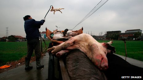
France is expected to suspend pig-related imports from a number of countries as worries grow over the spread of a deadly swine virus.
Porcine Epidemic Diarrhoea Virus (PEDv) has killed some seven million piglets in the US in the past year.
The disease has also been found in Canada, Mexico and Japan.
While the virus isn't harmful to humans or food, France is concerned over the potential economic impact and is set to suspend imports of live pigs and sperm.
Click on Image to Enlarge
PEDv is spread in faecal matter and attacks the guts of pigs, preventing them from absorbing liquids and nutrients.
Older animals can survive but fatality rates among piglets run between 80% and 100%.
So virulent is the agent that one expert estimated that a spoonful of infected manure would be enough to sicken the entire US herd.
The disease is believed to have its origins in China, according to the World Organisation for Animal Health (OIE).
“According to the information from genetic analyses, there is some similarity with a strain from Asia,” director-general Dr Bernard Vallat told BBC News.
“But the evidence of the crossing from Asia to the US is not yet established. For the moment it is not possible to make a final conclusion on the formal link, it is a suspicion.”
In North America, the disease has moved rapidly, with around 4,000 outbreaks in 30 US states, in four Canadian provinces and in parts of Mexico.
The Ocean Energy Turbine is important because it is the first renewable energy system designed to effectively harness ocean currents on a commercial scale. Globally, ocean currents can provide the power to completely replace the worlds dependance on fossil fuels and nuclear energy. The quantity of energy available from ocean energy greatly exceeds that of wind and solar. Ocean energy production is also a consistent reliable source of energy, whereas solar and wind power are limited by the availability of sun and wind.
It is impossible to have a rational conversation about climate change in the U.S. Congress or in Red value state legislatures, but in Blue value coastal states the implications of climate change and sea level rise are becoming a major issue, as this report explains.
As New Jersey residents loft their rebuilt homes onto five foot pilings along the shore and NYC Mayor Bill de Blasio promises to get work started on 500 storm-demolished homes before Hurricane Sandy’s two year anniversary, a new sea level rise analysis has found that $32 billion in property and 84,000 people are at risk of extreme coastal flooding in five New England states.
As part of its Surging Seas initiative, Climate Central is using data from federal agencies like the National Oceanic and Atmospheric Administration, the Environmental Protection Agency and the U.S. Geological Survey, among many others, to map sea level rise by zip code in an interactive tool that also shows the number of people and the value of the property at risk.
The mapping tool was launched in 2012 for New York, New Jersey and Florida. Now, data on Massachusetts, Rhode Island, New Hampshire, Maine and Connecticut is also available. Of the states just added to the map, Connecticut has the highest value of property at risk from coastal flooding – $14.9 billion. For its part, Massachusetts has about 47,888 people who would be endangered by a four-foot flood. The odds of such a flood occurring in Boston in the next 15 years is 67 percent. Most at risk are the 17,662 people who are highly vulnerable to flooding because of their social and economic situations.
You probably haven’t heard of Helen Slottje, or, for that matter, of her husband, David. But in the past few years, the former corporate lawyers have become arguably two of the most powerful opponents of fracking in New York – not to mention the most successful. As the (sort of) public face of the duo’s efforts, Helen Slottje on Monday was honored with the Goldman Prize, the world’s largest environmental prize.
Like most fracktivists, the Slottjes became embroiled in the issue when they moved to an area targeted by drilling companies – in their case, upstate New York, which sits atop the gas-rich Marcellus Shale, and where Gov. Andrew Cuomo has repeatedly put off making a decision about whether to lift the state’s five-year moratorium on hydraulic hydrofracking. Lacking confidence in the power of the picket sign or citizen engagement on oil-funded big government, they instead decided to approach the program at the most basic level. Their weapon of choice is a principle known as home rule: If individual communities decide that these industries pose a significant risk to common resources like air and water, then those communities can decide to keep those industries out, regardless of what state and federal laws say.
One by one, the Slottjes have helped small towns in New York enact such bans, to the point at which, even if New York’s moratorium were to be lifted tomorrow, the oil and gas industry would find itself effectively barred from drilling in 172 communities. After being decided in the towns’ favors at all of the state’s lower courts, two of those cases, in Dryden and Middlefield, are now up before the Court of Appeals. A decision, which will determine whether towns have the right to override state law, is expected this fall, and its anticipated impact can’t be overstated. As Thomas West, a lawyer for the energy company seeking to have the ban overturned, told the New York Times last year, ‘It’s going to decide the future of the oil and gas industry in the state of New York.” (The Slottjes, it should be noted, weren’t even mentioned in the piece.)