Patrick Meier: Crisis Mapping without GPS Coordinates

Crowd-Sourcing, Data, Design, Geospatial, Innovation
Patrick Meier
Patrick Meier

Crisis Mapping without GPS Coordinates

I recently spoke with a UK start-up that is doing away with GPS coordinates even though their company focuses on geographic information and maps. The start-up, What3Words, has divided the globe into 57 trillion squares and given each of these 3-by-3 meter areas a unique three-word code. Goodbye long postal addresses and cryptic GPS coordinates. Hello planet.inches.most. The start-up also offers a service called OneWord, which allows you to customize a one-word name for any square. In addition, the company has expanded to other languages such as Spanish, Swedish and Russian. They’re now working on including Arabic, Chinese, Japanese and others by mid-January 2014. Meanwhile, their API lets anyone build new applications that tap their global map of 57 trillion squares.

When I spoke with CEO Chris Sheldrick, he noted that their very first users were emergency response organizations. One group in Australia, for example, is using What3Words as part of their SMS emergency service. “This will let people identify their homes with just three words, ensuring that emergency vehicles can find them as quickly as possible.” Such an approach provides greater accuracy, which is vital in rural areas. “Our ambulances have a terrible time with street addresses, particularly in The Bush.” Moreover, many places in the world have no addresses at all. So What3Words may also be useful for certain ICT4D projects in addition to crisis mapping. The real key to this service is simplicity, i.e., communicating three words over the phone, via SMS/Twitter or email is far easier (and less error prone) than dictating a postal address or a complicated set of GPS coordinates.

Source with Graphics

Jean Lievens: Can the Internet Democratize Capitalism?

Advanced Cyber/IO, Civil Society, Cultural Intelligence, Ethics, Government, Money
Jean Lievens
Jean Lievens

Can the Internet Democratize Capitalism?

Yanis Varoufakis

International Policy Digest,

Technological fixes to time-honoured problems are all the rage these days.

Bitcoin is meant to fix money, social media are seen as an antidote to Rupert Murdoch and assorted tyrants, networked robots are to help countries like Japan deal with demographic declines etc. Perhaps the largest claim is that the Internet has helped (or is about to help) democratize capitalism. Ten years ago that claim struck me as both fascinating and dubious. So, I sat down and wrote an article about it (circa 2004). Its gist: The Internet is a wonderful leveller.

But democracy requires a great deal more than mere ‘levelling.’ Primarily, it requires political institutions that enable the economically weak to have a decisive say on policy against the interests of the rich and powerful. Ten years later, I am re-visiting this question, under the shadow of a global crisis that made it even harder to convert an e’Demos into genuine e’Democracy. What follows is an updated version of the original paper.

The Internet’s toughest assignment: To put Demos back into Democracy

Continue reading “Jean Lievens: Can the Internet Democratize Capitalism?”

Patrick Meier: Using Crowd Computing to Analyze UAV Imagery for Search & Rescue Operations — Starkly Opposite USAF Gorgon Stare in Cost, Utility, & Sensibility

Crowd-Sourcing, Innovation, Mobile, Sources (Info/Intel)
Patrick Meier
Patrick Meier

Using Crowd Computing to Analyze UAV Imagery for Search & Rescue Operations

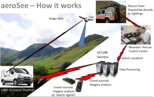
My brother recently pointed me to this BBC News article on the use of drones for Search & Rescue missions in England’s Lake District, one of my favorite areas of the UK. The picture below is one I took during my most recent visit. In my earlier blog post on the use of UAVs for Search & Rescue operations, I noted that UAV imagery & video footage could be quickly analyzed using a microtasking platform (like MicroMappers, which we used following Typhoon Yolanda). As it turns out, an enterprising team at the University of Central Lancashire has been using microtasking as part of their UAV Search & Rescue exercises in the Lake District.

Click on Image to Enlarge

Every year, the Patterdale Mountain Rescue Team assists hundreds of injured and missing persons in the North of the Lake District. “The average search takes several hours and can require a large team of volunteers to set out in often poor weather conditions.” So the University of Central Lancashire teamed up with the Mountain Rescue Team to demonstrate that UAV technology coupled with crowdsourcing can reduce the time it takes to locate and rescue individuals.

Continue reading “Patrick Meier: Using Crowd Computing to Analyze UAV Imagery for Search & Rescue Operations — Starkly Opposite USAF Gorgon Stare in Cost, Utility, & Sensibility”

Berto Jongman: How visualising data has changed life…and saved lives

Data, Design
Berto Jongman
Berto Jongman

How visualising data has changed life… and saved lives

From John Graunt's ‘bills of mortality' to Florence Nightingale's revolutionary ‘rose charts', the distillation of information into graphics has been a vital tool for scientists

Nicola Davis

The Observer, Saturday 15 February 2014

Big data, infographics, visualisations – the pop words of a modern phenomenon. But while information accumulation has become a 21st-century obsession, our generation is not the first to discover that a picture is worth a thousand words, as a new British Library exhibition will reveal.

Revelling in the power of illustrations, tables and figures, Beautiful Science charts the course of data dissemination across the centuries, from the grim ledgers of death recorded by John Graunt in the 17th-century “bills of mortality” to the digital evolutionary tree dreamt up by an Imperial College researcher, complete with a mind-boggling zoomable function. “You can use almost fractal-like patterns to explore all of life on Earth,” says Dr Johanna Kieniewicz, lead exhibition curator.

Continue reading “Berto Jongman: How visualising data has changed life…and saved lives”

Patrick Meier: Crisis Mapping in Areas of Limited Statehood

Crowd-Sourcing, Geospatial, Governance
Patrick Meier
Patrick Meier

Crisis Mapping in Areas of Limited Statehood

I had the great pleasure of contributing a chapter to this new book recently published by Oxford University Press: Bits and Atoms: Information and Communication Technology in Areas of Limited Statehood. My chapter addresses the application of crisis mapping to areas of limited statehood, drawing both on theory and hands-on experience. The short introduction to my chapter is provided below to help promote and disseminate the book.

Continue reading “Patrick Meier: Crisis Mapping in Areas of Limited Statehood”

Ecuador Initiative: Commons-Oriented Productive Capacities

Culture, Design, Governance, Innovation, Knowledge, Resilience
Click on Image to Enlarge

ECUADOR INITIATIVE: Transition Proposals Toward a Commons-Oriented Economy and Society

Sponsored by the National Institute of Advanced Studies of Ecuador, carried out by the Free/Libre Open Knowledge (FLOK) Society.

Commons-oriented Productive Capacities

See Also:

Ecuador Initiative @ Phi Beta Iota

Michel Bauwens @ Phi Beta Iota

Ecuador Initiative: Limits of Economic Valuations of Nature

Culture, Design, Governance, Knowledge, Resilience
Click on Image to Enlarge

ECUADOR INITIATIVE: Transition Proposals Toward a Commons-Oriented Economy and Society

Sponsored by the National Institute of Advanced Studies of Ecuador, carried out by the Free/Libre Open Knowledge (FLOK) Society.

From Jose Luis Vivero Pol

BIOMOT Policy Brief 1 – Limitations to Economic Environmental Valuation

1. EEV methods fail to secure ecosystem systainability.

2. EEV methods mistakenly assume that money can be used as a neutral measuring rod of people's preferences.

3. EEV methods are grounds in a misguided approach to decision making.

4. EEV methods misunderstand, and motivate policies which fail to respect, the way in which people value nature.

5. EEV methods may compromise intrincis motivations for environmental protection.

6. EEV methods facilitate the troubling expansion of market norms into environmental valuation and decision making.

Continue reading “Ecuador Initiative: Limits of Economic Valuations of Nature”