Journal: US Response to Haiti Reveals Old Mindsets

Collaboration Zones, Communities of Practice, Ethics, Geospatial, InfoOps (IO), Key Players, Methods & Process, Mobile, Policies, Real Time, Reform, Strategy, Threats, Tools
Full Story Online

The Right Testicle of Hell: History of a Haitian Holocaust

By Greg Palast

Blackwater before drinking water

6. From my own work in the field, I know that FEMA has access to ready-to-go potable water, generators, mobile medical equipment and more for hurricane relief on the Gulf Coast. It's all still there. Army Lt. Gen. Russel Honoré, who served as the task force commander for emergency response after Hurricane Katrina, told the Christian Science Monitor, “I thought we had learned that from Katrina, take food and water and start evacuating people.” Maybe we learned but, apparently, Gates and the Defense Department missed school that day.

7. Send in the Marines. That's America's response. That's what we're good at. The aircraft carrier USS Carl Vinson finally showed up after three days. With what? It was dramatically deployed — without any emergency relief supplies. It has sidewinder missiles and 19 helicopters.

8. But don't worry, the International Search and Rescue Team, fully equipped and self-sufficient for up to seven days in the field, deployed immediately with ten metric tons of tools and equipment, three tons of water, tents, advanced communication equipment and water purifying capability. They're from Iceland.
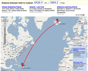
Any Questions?

Phi Beta Iota: This is what we were thinking of when we laid out the CAB 21 Peace Jumpers scenario.  The Pentagon is out of touch with reality because they have such a narrow mind-set that is uninformed about the possibilities and simply does not compute Whole of Government resourcing or clean drinking water as a security device vastly more effective than a Marine standing guard over nothing.  With all humility, if DIA goes not get its act together in the Open Source Intelligence (OSINT) and Multinational Engagement arena, and help the Pentagon learn about the new craft of waging peace with Whole of Government non-secret campaign plans and multinational virtual harmonization of resource needs identification and fulfulfillment at the Twitter level, we will continue to fail ourselves and everyone else.  As we pointed out early on, Haiti's disaster was/is an OPPORTUNITY.   Evidently no one in the Pentagon is thinking that way.

See also:  Journal: Haiti Rolling Update (Chronology with Links)

Journal: Haiti Public Intelligence Emergent

08 Wild Cards, Analysis, Budgets & Funding, Collaboration Zones, Communities of Practice, Ethics, Geospatial, InfoOps (IO), IO Mapping, Methods & Process, Mobile, Policies, Real Time, Threats, Tools

Full Story Online

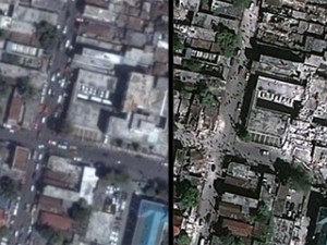
Google Maps updates with new Haiti pics: Hours-old satellite images show destruction

Google has released a new KML overlay — tech speak for map layer — that includes fresh images of Port-au-Prince.

According to GeoEye , the satellite imagery company that provided the photos, they were taken at 10:30 a.m. yesterday from a satellite 423 miles up.

By toggling the new image layer on and off, it’s easy to compare what the city looked like before the earthquake with the way it looks now.

Aside from the obvious destruction, one of the most striking features of the new images is the large number of presumably homeless people in the streets of the ruined neighborhoods.

Click here to see the new images in Google Maps.

Phi Beta Iota: Finally, but kudos never-the-less.  This should always be the first thing done, perhaps with a global arrangement that has regional cost-sharing in place and can use military air breathers where commercial are not immediately available, but respecting Google's software and end-user delivery offering.  There is still the matter of getting to shared Spacial Reference Systems (SRS).  This could and should be used to “plot” Twitter messages that identify need, and in the back office, matching RapidSMS messages that can be aggregated to fund need resolution.

Where Are Haiti Earthquake Relief Funds Going?

Millions in donations have been raised since the earthquake in Haiti on Tuesday, but where is the money going?

Like Wyclef Jean's Yele Haiti which is urging people to text “Yele” to 501501 to donate $5 to the cause — which has raised more than $2 million so far — many other relief organizations have used mobile messaging to quickly gather funds.

Phi Beta Iota: What is most interesting about this is the fact that fund-raising (financial incentive for the organizers that take a 5% to 50% “cut) is very well developed and moving money, while the other end (requirements definition, logistics coordination, and “by household” delivery” is NOT developed at all.  This is a good start toward the Global to Local Range of Needs Table, when that is developed, this will “flip” in that people will give for SPECIFIC itemized needs, not as a leap of faith in intermediaries that generally do NOT deliver full value.

What is LACKING is a single trusted Multinational Decision Support Center with both regional and global non-profit “cachet” as well as two-way reachback into all eight tribes of all nations, that can be the single point orchestrating the receipt and integration of all information in all languages in near-real-time, and the trusted point for validating both needs and the resolution of needs through the application of fundss.

See Also:

Continue reading “Journal: Haiti Public Intelligence Emergent”

Journal: Haiti–Twitter Rocks

03 Environmental Degradation, Geospatial, Gift Intelligence, IO Mapping, IO Sense-Making, Methods & Process, Mobile, Peace Intelligence, Tools

Phi Beta Iota: Now imagine a global public fully aware of the value of Twitter photos with geospatial attributes, and a multinational decision support team able to receive and plot all such contributions….  As long as “research” is controlled by secret and ultra-far out organizations like DARPA and IARPA this stuff is not going to be applied practically.   Civil Affairs Brigade (CAB) and its Joint Civil Information Management (JCIM), combined with a United Nations Open-Source Decision-Support Information Network (UNODIN), a Union of South American Nations (UNASUR) Information Network, and a Multinational Decision Support Center (MDSC) would go a long way toward getting an immediate grip on all this, in detail, and then creating a Haiti Needs Table at the household level that could be triaged out (see Graphic: Global Range of Nano-Needs for the idea).

Highlights

Major quake hits Haiti; many casualties expected

Karel Zelenka, a Catholic Relief Services representative in Port-au-Prince, told U.S. colleagues before phone service failed that “there must be thousands of people dead,” according to a spokeswoman for the aid group, Sara Fajardo.

With phones down, some of the only communication came from social media such as Twitter. Richard Morse, a well-known musician who manages the famed Olafson Hotel, kept up a stream of dispatches on the aftershocks and damage reports.

Haiti earthquake — what we're hearing

CNN is monitoring tweets and other messages from people in Haiti and reports from those who said they have been in touch with friends and family. CNN has not been able to able to verify this material.

“If anyone in Haiti is reading this, please go out and help in the streets, it's very ug;y out there if you haven't seen it #haiti” –From Twitter user fredodupoux in Haiti at 8:04 p.m. ET

“Tipap made it home from Carrefour – saw many dead bodies and injured along the way – said most buidings w/more than one story are down” — From Twitter user troylivesay in Port-au-Prince, Haiti, at 8:22 p.m. ET


Fears of major catastrophe as 7.0 quake rocks Haiti

AFP/Twitter – This image obtained from Twitter purportedly shows Haitians standing amid rubble on January 12 in Port-au-Prince. …

A local doctor told an AFP reporter in the city that hundreds of people are feared dead.

A local UN employee said the earthquake had destroyed the headquarters of the United Nations peacekeeping mission in the country.

Seventy percent of Haiti's population lives on less than two dollars per day and half of its 8.5 million people are unemployed.

According to official figures, food insecurity already affects more than a quarter of Haiti's population, some 1.9 million people, with women and children the worst affected.

Twitter Has First Pictures Of Haiti Earthquake

News is still coming in from Haiti even thought night as fallen. Shortly after the quake, our first look at the devastation was given to us via social media websites like Twitter and Facebook.

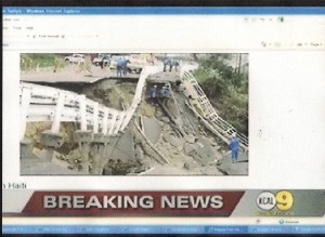
1st Look At Devastation In Haiti Quake
Tue Jan 12, 10:51AM PT – CBS 2 / KCAL 9 Los Angeles 0:54 | 33138 views

Definitions: Spatial Referencing System (SRS)

Definitions, Geospatial
Wikipedia Page

A spatial referencing system (SRS) or coordinate reference system (CRS) is a coordinate-based local, regional or global system used to locate geographical entities. Some of systems in existence are:

Related References:

01 OMB Circular A-16 SUBJECT: Coordination of Geographic Information and Related Spatial Data Activities, August 19, 2002

02  UN Global Map Specifications (2006 Memorandum)

03  OpenGIS® Standards and Related OGC documents

04  OGC Reference Model (ORM)

05  TerraSeer Space-Time Intelligence System™

Continue reading “Definitions: Spatial Referencing System (SRS)”

Reference: Intelligence-Led Peacekeeping

Analysis, Budgets & Funding, Collective Intelligence, Communities of Practice, DoD, Earth Intelligence, Ethics, Geospatial, InfoOps (IO), Key Players, Methods & Process, Peace Intelligence, Policies, Policy, Real Time, Reform, Strategy, Threats, United Nations & NGOs
Dorn on UN PKI Haiti FINAL

Professor Walter Dorn is the virtual Dean of peacekeeping intelligence scholarship, going back to the Congo in the 1960's when Swedish SIGINT personnel spoke Swahli fluently and the UN stunned the belligerents with knowledge so-gained.  This is the final published version of the article posted earlier in author's final draft.

The UN is now ready for a serious discussion about a United Nations Open-Source Decision-Support Information Network (UNODIN) but a Member nation must bring it up, as the Secretary General has kindly informed us in correspondence.

In the absence of US interest, we are asking Brazil, China, and India to bring it up.  Should a UNODIN working group be formed, it will certainly include African Union (AU), Union of South American Nations (UNASUR), and Shanghai Cooperation Organization (SCO) counterpart groups, as the regional networks will do the heavy lifting and be the super-hubs for the UN (this is in contrast to a US DoD-based system in which military-to-military hubs would be established to do two-way reachback among the eight tribes in the respective nations).  Both concepts are explored in the new book, INTELLIGENCE FOR EARTH and in two DoD briefings that are also relevant to the QDR.

Worth a Look: MapAction Emergency Deployment Service

Geospatial, Worth A Look
Home Page

East View Cartographic has been and remains our preferred provider of emergency geospatial services, but we like what we see here at MapAction, which appears to be popular in meeting United Nation (UN) needs, so we show them today as Worth a Look.

Sample Entry:

MapAction has published the first edition of its Field Guide to Humanitarian Mapping. The guide, which is downloadable free, will help aid organisations to use geospatial tools and methods in their work in emergencies. There are tutorials for Google Earth and open-source GIS software. Click here to access the guide.

The guide was written to meet the need for practical, step-by-step advice for aid workers who wish to use free and open-source resources to produce maps both at field and headquarters levels. The first edition contains an introduction to the topic of GIS, followed by chapters focused on the use of two recommended free software tools: Google Earth, and MapWindow. However much of the guidance is also relevant for users of other software. In addition there is a chapter on using GPS to collect data during humanitarian emergencies.

The principal author of the guide, MapAction team member Naomi Morris, commented: “We will be trialing the first edition during a three-month mission to Papua New Guinea in which we will show local organisations how to use these methods for disaster risk reduction mapping. More widely, we will welcome input from all our humanitarian organisations and a second edition of the guide will be issued later this year.”

The guide is available free as a PDF download (118 A5-sized pages) from our Resources page or by clicking here. In case of difficulty contactinfo@mapaction.orgThis e-mail address is being protected from spambots. You need JavaScript enabled to view itand a copy can be emailed. We also welcome user feedback and suggestions for content to be included in the next edition.

Production of the guide was funded by the Dulverton Trust.

Reference: Countries at the Crossroads

Geospatial, United Nations & NGOs

Countries at the Crossroads is an annual survey of government performance in 70 strategically important countries worldwide that are at a critical crossroads in determining their political future. The in-depth comparative analyses and quantitative ratings – examining government accountability, civil liberties, rule of law, anticorruption efforts and transparency – are intended to help international policymakers identify areas of progress, as well as to highlight areas of concern that could be addressed in diplomatic efforts and reform assistance.

A new edition of Crossroads is published each year, with one set of 35 countries analyzed in odd years and the other 35 in even years. Crossroads reports are written and evaluated by some of the most prominent independent experts available for each country.

Lists  by Region

The Interactive map color-codes all Crossroads countries based on their government performance, and provides policy recommendations and each country's status in the Millennium Challenge Account process. By clicking on the hyperlink within the pop-up boxes, users can access the most recent country reports.

2006/2007 Interactive Map

Countries at the Crossroads Blog

Phi Beta Iota: As recommended by Berto Jongman.  These countries are precisely what General Al Gray, then Commandant of the Marine Corps, was thinking about when he advocated, in 1989, that we get serious about “peaceful preventive measures.”