Reference: Map of Multilateral Peace Operation Deployments

Geospatial, United Nations & NGOs

SIPRI Map of Multilateral Peace Operation Deployments

Click to enlarge
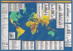
This SIPRI map presents a snapshot of multilateral peace operation deployments worldwide in September 2009. Using data drawn from the SIPRI Multilateral Peace Operations Database, it shows where missions are taking place, how large they are and which organizations and coalitions are conducting them.
Download this SIPRI Map.

Publisher: SIPRI
1 page (A3)
November 2009

Phi Beta Iota: Berto Jongman recommends this.  All of these operations are what we envisioned being supported with M4IS2 out of the embedded Multinational Decision Support Center within the Defense Open Source Center as described in 2009 DoD OSINT Leadership and Staff Briefings.

See also:

Continue reading “Reference: Map of Multilateral Peace Operation Deployments”

Journal: Four-Dimensional Digital Maps

Analysis, Budgets & Funding, Collaboration Zones, Communities of Practice, Ethics, Geospatial, Key Players, Methods & Process, Mobile, Policies, Real Time, Threats
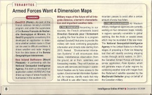
Four Dimensional Digital Maps

The graphic can be enlarged.  Two key points:

1.  We are finally getting to where geospatial and functional data can be merged in near-real-time.

2.  Intelligence Online remains our only “must read”

The question that is NOT being addressed is this one:  What will it take to create an infinitely scalable and drillable digital map of the Earth, using open source software and open to all, to which all manner of data in all languages can be appended, validated, and integrated?

Journal: ClimateGate Ideology, Theology, Science

03 Environmental Degradation, Analysis, Budgets & Funding, Communities of Practice, Earth Intelligence, Ethics, Geospatial, Key Players, Methods & Process

Chuck Spinney
Chuck Spinney

Chuck Spinney Sends: Viewed at the level of epistemology, the distinction be the search for truth in science and religion is stark:
In science the structure of the world view — i.e., the brain's interior model of reality — is evolved to match observations taken from the external world, whereas in religion, observations are evolved to match a fixed world view inserted into the brain by some kind of deity.
Miracles (anomalies that defy the model's definition of reality) might be explained by or at least rationalized within an unquestionable dogma of a religious model, whereas such anomalies in science trigger a search for tests that falsify the model.   In terms of this typology, the recent scandal involving hacked emails of the UK's Climate Research Center at the University of East Anglia raises a basic question of whether global warming theory is being shaped by a predominantly scientific or religious mindset.

Worth a Look: Ushandi Open Source Crowd-Sourcing

Collaboration Zones, Communities of Practice, Ethics, Geospatial, InfoOps (IO), Key Players, Methods & Process, Mobile, Policies, Real Time, Technologies, Threats, Worth A Look
Ushandi Home Page
Ushandi Home Page

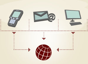
The Ushahidi Engine is a platform that allows anyone to gather distributed data via SMS, email or web and visualize it on a map or timeline. Our goal is to create the simplest way of aggregating information from the public for use in crisis response.

Usahndi Visual Concept

This is a huge development, one that could lead to a more rapid creation of the World Brain with embedded EarthGame as a means of connecting all human minds with all information in all languages all the time.

See our briefing given in Denmark to think about how this might apply to the global harmonization of gifts from the one billion rich to needs of the five billion poor at the household and item level.

Review: GIS for Decision Support and Public Policy Making

5 Star, Best Practices in Management, Change & Innovation, Complexity & Resilience, Decision-Making & Decision-Support, Disaster Relief, Games, Models, & Simulations, Geography & Mapping, Geospatial, History, Humanitarian Assistance, Information Operations, Information Society, Information Technology, Intelligence (Government/Secret), Intelligence (Public), Peace, Poverty, & Middle Class, Stabilization & Reconstruction, Strategy, True Cost & Toxicity, Truth & Reconciliation, Values, Ethics, Sustainable Evolution, Voices Lost (Indigenous, Gender, Poor, Marginalized), War & Face of Battle, Water, Energy, Oil, Scarcity

Amazon Page
Amazon Page

ESRI Sales Material, Excellent Price, Recommended,

July 20, 2009
Christopher Thomas and Nancy Humenik-Sappington
As a publisher who is also an author, I continue to be outraged by the prices being charged for “trade” publications. This book is properly-priced–other books on GIS I would have bought are priced at three to four times their actual value, thus preventing the circulation of that knowledge. Those publishers that abuse authors and readers refuse to respect the reality that affordably priced books are essential to the dissemination of knowledge and the perpetuation of the publishing industry.

The book loses one star for refusing to address Google Earth and elements of the Google offering in this industry space. While Google is predatory and now under investigation by the anti-trust division of the Department of Justice, to ignore Google and its implications for cloud management of data in geospatial, time, and other cross- cutting contests, is the equivalent of poking one eye out to avoid seeing an approaching threat.

Having said that, I found this book from ESRI charming, useful, and I recommend it very highly, not least because it is properly priced and very well presented. Potential clients of ESRI can no doubt get bulk deliver of this volume for free.

Return on Investment factors that ESRI highlights up front include:
+ Cost and times savings
+ Increased efficiency, accuracy, productivity of existing resources
+ Revenue generation
+ Enhanced communications and collaboration
+ Automated workflows
+ More efficient allocation of new resources
+ Improved access to information.

The book consists of very easy-to-read and very well-illustrated small case studies, most previously published in Government Matters, which appears to be a journal (there are a number listed by that title).

Here are the highlights of this book for me personally:

+ Allows for PUBLIC visualization of complex data
+ Framework for “seeing” historical data and trends
+ Value of map-based dialog [rather than myth-based assertions]
+ Allows for the visualization of competing perspectives past and future
+ Illuminated land population dynamics, I especially like being able to see “per capita” calculations in visual form, especially when per capita can also be sliced by age, sex, income, religion, race, and so on.
+ Mapping derelict vessels underwater is not just a safety function, but opens the way for volunteer salvage and demolition
+ GROWS organically by attracting new data contributors who can “see” the added value of contributing their data and then being able to see their data and everyone else's data in geospatial terms. This is a POWERFUL incentive for information-sharing, which more often than not receives lip service. GIS for me is the “key” to realizing sharing across all boundaries while also protecting individual privacy
+ Shows “pockets” of need by leveraging data gaps in relation to known addresses (e.g. immunizations, beyond 5 minute fire response, etc.)'
+ Gives real meaning to “Intelligence Preparation of the Battlefield (IPB)” and–not in this book–offers enormous potential if combined with a RapidSMS web database that can received text messages from hundreds of thousands of individuals across a region
+ Eliminates the time-energy cost of data collection in hard copy and processing of the individual pages into an aggregate database.

The book discusses GIS utility in the routing of hazardous materials, but avoids the more explosive (pun intended) value of GIS in showing the public as well as government officials where all the HAZMAT is complacently stored now. For a solid sense of the awaiting catastrophe, see my review of The Next Catastrophe: Reducing Our Vulnerabilities to Natural, Industrial, and Terrorist Disasters.

The book also avoids any discussion of the urgency as well as the value of GIS in tracking and reducing natural resource consumption (e.g. water usage visible to all house by house), and the enormous importance of rapidly making it possible for any and all organizations to channel their data into shared GIS-based aggregations. For a sense of World Brain as EarthGame, see my chapter in Collective Intelligence: Creating a Prosperous World at Peace the chapter is also free online at the OSS.Net, Inc. website forward slash CIB.

This book, 189 pages of full color, is a righteous useful offering. I would encourage ESRI to become the GIS publisher of choice, buy out the titles that I could not afford, and enter the business of affordable aggregate publishing in the GIS field. Other titles by ESRI on GIS:
Measuring Up: The Business Case for GIS
The GIS Guide for Local Government Officials
Zeroing in: Geographic Information Systems at Work in the Community

Five other cool books on data pathologies that GIS can help resolve:
The Landscape of History: How Historians Map the Past
Fog Facts : Searching for Truth in the Land of Spin (Nation Books)
Lost History: Contras, Cocaine, the Press & ‘Project Truth'
Forbidden Knowledge: From Prometheus to Pornography
The Age of Missing Information (Plume)

The latter remind me that GIS will not blossom fully until it can help the humanities deal with emotions, feelings, and perceptions across tribal and cultural boundaries. Right now, 23 years after I first worked with GIS in the Office of Information Technology at CIA, GIS is ready for the intermediate leap forward: helping multinational multiagency data sets come together. ESRI has earned deep regard from me with this book and I will approach them about a new book aimed at the UN, NGOs, corporations, and governments that wish to harmonize data and in so doing, harmonize how they spend across any given region, e.g. Africa. This will be the “master leap” for GIS, enabling the one billion rich to respond to micro-needs from the five billion poor, while also increasing the impact of aggregated orchestrated giving by an order of magnitude.

ESRI: well done!

Vote on Review
Vote on Review

Click Here to Vote on Review at Amazon,

on Cover Above to Buy or Read Other Reviews,

I Respond to Comments Here or There

Geospatial Archives on Public Intelligence (1992-2006)

Geospatial
CD  Needs for PKI
CD Needs for PKI

2005

US

Geospatial East View Sudan Tactical Map Availability

2005

US

Geospatial East View Liberia Tactical Map Availability

2005

US

Geospatial East View Ivory Coast Tactical Map Availability

2005

US

Geospatial East View DRC Congo Russian Map Availability

2005

US

Geospatial East View DRC Congo Large Scale Map Availability

2005

US

Geospatial East View DRC Congo NIMA 250K Map Availability

2005

US

Geospatial East View DRC Congo National 200K Map Availability

2005

US

Geospatial East View Burundi Tactical Map Availability

2005

US

Geospatial East View Afghanistan Military Maps

2005

US

Geospatial East View Eastern Congo Priority Tactical Map Deficiencies

2004

US

Geospatial East View Aceh Indonesia 1:50,000 Tactical Map Availability

2004

US

Geospatial East View Aceh Indonesia 1:250,000 Large Scale Map Availabiility

2003

US

Geospatial East View Iraq Post-Conflict Map Availability

2003

US

Geospatial NAPA Geographic Information for the 21st Century

1999

US

Geospatial Steele Real-World Mapping Shortfalls (Two Slides)