Worth a Look: GeoChat (SMS Plotted on Map)

Collective Intelligence, Communities of Practice, Geospatial, Mobile, Peace Intelligence, Policies, Real Time, Technologies, Threats, Tools, Worth A Look
Collaboration Tool

GeoChat emerged from a simple concept – can I send an SMS message and see it on a map?

From there the concept has evolved, and geochat has become a project to build a collaboration platform from the lowest common denominator communication tools, considering as highest priorities the needs of workers of humanitarian aid, international health and disaster response.

The main drivers for the project are the feedback of the InSTEDD programs in South East Asia, exercises such as GoldenShadow, and a growing community of humanitarian and health workers who spend their days in technologically austere environments. We invite anyone from any line of work to use and contribute user experience, technical, and any other kind of feedback.

Phi Beta Iota: InSTEDD [Innovative Support to Emergencies Diseases Disasters] is blessed with the participation of Cdr Eric Rasmussen, USN, a co-founder of STRONG ANGEL which has been allowed to die for all the wrong reasons.  He and Dr. Dr. Dave Warner are pioneers in M4IS2 [Multinational Multiagency Multidisciplinary Multidomain Information-Sharing and Sense-Making.]  See also UNICEF's RapidSMS.

Event: 16-18 July 2010 NYC NY The Next Hope

Collective Intelligence, Communities of Practice, Computer/online security, Cultural Intelligence, Ethics, Geospatial, InfoOps (IO), Key Players, Methods & Process, Mobile, Policies, Real Time, Strategy, Technologies, Threats, Tools

HACKERS ON PLANET EARTH (HOPE)

The Next Hope (2010)

Pre-Registration Now Open

Call for Speakers

Links to Past HOPE Events

Phi Beta Iota: Hackers are like astronauts, pushing the bleeding edge of the envelope.  If the US Government had listened to us in 1991-1994, cyberspace would be secure today, and we would not be spending $12 billion a year on the cyber-scam game–outsourcing to beltway bandits fighting for the 100 folks that actually know how to do this stuff and can qualify for clearances.  Our solution for the regional networks is gong to be multinational and open everything.  This event is specifically recommended for young teens who show signs of intelligence and curiosity, and for mid-career officers beginning to realize that 80% of what they do is without merit, seeking a better way.  This is where we do the right things righter, not the wrong things righter.

Photo Gallery (Yahoo) Photo Gallery (Google)

See also:

Continue reading “Event: 16-18 July 2010 NYC NY The Next Hope”

Journal: Real Time Intelligence in Two Way Energy Grid

Earth Intelligence, Key Players, Methods & Process, Mobile, Policies, Real Time, Technologies

NEW METER

Eltel Networks Smart Meters A Good Example for Middle East Countries to Follow

For those who are not aware of this technology, a smart grid delivers electricity from suppliers to consumers using two-way digital technology to control appliances at consumers’ homes to save energy, reduce cost and increase reliability and transparency.

NEW METER

It includes an intelligent monitoring system that keeps track of all electricity flowing through the system. A smart meter enables accurate electronic measuring of energy being used, and are much more accurate than standard meters which simply estimate the amount of energy being used. They enable the calculation of flexible energy tariffs that measure consumption over set time periods.

They also enable the capability of selling unused energy back to the supplier, i.e. the utility company, and will enable better usage of renewable energy technologies, such as solar panels and wind turbines.

Phi Beta Iota: It will probably take another twenty years, but “smart” grids are coming along.  The real break-through will be when “true costs” of every product and service are clearly visible at the press of a button on one's cell phonoe.  Open Spectrum is also inevitable, along with Open Money.  See the  Graphic: Open Everything.


Journal: GPS Finally Fully Integrated in Voice Comms

Geospatial, IO Mapping, Mobile, Tools

Full Story Online

Nokia Voice Nav Spells Doom For TomTom, Garmin

Jared Newman, PC World

Jan 21, 2010 4:18 pm

As Nokia takes on Google with turn-by-turn voice navigation on select smartphones, the worst nightmares of GPS device makers are coming true.

Nokia and Google are both using free GPS applications as a lure to their products. That means they're competing, which means those free applications will get better. As that happens, it'll be harder for TomTom, Garmin and Magellan to make their paid software or hardware seem attractive.

Already, Nokia claims to have one-upped Google in the crucial area of pre-loaded maps. While Google Maps Navigation requires a data connection, Ovi Maps uses a combination of pre-loaded and online maps, but can load directions even in a dead zone. When it does need to load information, Nokia says it's more efficient than Google's application, requiring only 200 KB of data over a 12-mile stretch of road compared with 2 MB for an Android phone.

Continue reading “Journal: GPS Finally Fully Integrated in Voice Comms”

Journal: Intelligence & Innovation Support to Strategy, Planning, Programming, Budgeting, & Acquisition

Analysis, Budgets & Funding, Collaboration Zones, Communities of Practice, Ethics, Geospatial, History, InfoOps (IO), Information Operations (IO), Key Players, Methods & Process, Mobile, Policies, Policy, Real Time, Reform, Strategy, Technologies, Threats, Tools, True Cost
Robert David STEELE Vivas

Chuck Spinney is still the best “real” engineer in this town–almost everyone else is staggering after fifty years of government-specification cost-plus engineering.  Also, as Chuck explores in the piece on Complexity to Avoid Accountability is Expensive we in the “requirements” business are as much to blame–Service connivance with complexity has killed acquisition from both a financial inputs and a war-fighting relevance outcome point of view.  The Services have forgotten the basics of requirements definition and multi-mission interoperability and supportability.

The Marine Corps Intelligence Center (MCIC) was created by General Al Gray, USMC (Ret), then Commandant of the Marine Corps, for three reasons:

1.  Intelligence support to constabulary and expeditionary operations from the three major services was abysmal to non-existent.

2.  Intelligence  support to the Service level planners and programmers striving to interact with other Services, the Unified Commands, and the Joint Staff was non-existent–this was the case with respect to policy, acquisition, and operations.  The cluster-feel over Haiti and the total inadequacy of our 24-48 hour response tells us nothing has changed, in part because we still cannot do a “come as you are” joint inter-agency anything.

Continue reading “Journal: Intelligence & Innovation Support to Strategy, Planning, Programming, Budgeting, & Acquisition”

Journal: Haiti Op-Eds

08 Wild Cards, Collaboration Zones, Communities of Practice, Methods & Process, Mobile, Policies

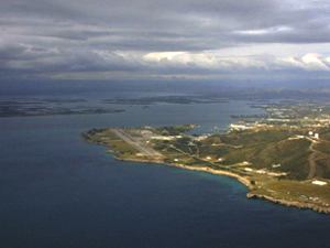
Guantanamo Base

Guantanamo To The Rescue

The base has two airfields, a state-of-the-art communication system and brand-new water and sewage lines that could accommodate as many as 45,000 refugees. And the base is large enough to stage an aid effort without impinging on prison operations.

Put The Pentagon In Charge

The other truth is that the only entity on the planet with the capacity to bring help to Haiti on the scale needed is the U.S. military. The United Nations will find it impolitic to admit this; the big international relief groups, proud of their noncombatant status, will shy from acknowledging it. But it is the reality

Frictions Between Nations Rise Over Struggle Of Getting Aid To Haiti

But there were growing tensions over which country's planes were allowed to land here first, with each nation insisting its aid flight was a priority, according to an official involved in the relief operation.

France, Brazil and Italy were said to be upset, and the Red Cross said one of its planes was diverted to Santo Domingo, the capital of neighboring Dominican Republic.

Le Bret said that the Port-au-Prince airport has become “not an airport for the international community. It is an annex of Washington.”

Phi Beta Iots: Haiti is an Information Operations (IO) challenge.  Obviously the Pentagon is not addressing it as such, so they will continue to have log-jams because they are not pushing the “information perimeter” out to the take-off and loading points.  A needs matrix should be in place, and the stuff should be coming in via four landing masters (Air Wheels, Air Drop, Beach, Road) with an intelligence-driven load and deliver flow plan.  This is not rocket science.  It just takes the right mind-set and a global C4I grid that DoD does not have at the same time that it refuses to use the obivous existing public networks.

See also: Journal: Haiti Rolling Update (Chronology with Links)

Journal: Haiti Earthquake Unconventional C4I

08 Wild Cards, Civil Society, Collective Intelligence, Gift Intelligence, IO Mapping, IO Multinational, IO Sense-Making, Methods & Process, Mobile, Non-Governmental, Peace Intelligence, Real Time, Technologies, Tools

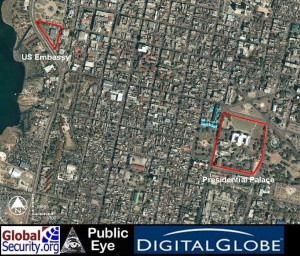
Sample Commercial Image

Apps for Haiti: An SMS 911, a People Finder, and more to come

Haiti Earthquate Person Registry (Seeking/Found) (Merged with Google Person Finder)

Spreadsheet of 152 Organizations Rendering Aid to Haiti

Wikipedia Page Participants on the Ground and Unconventional Communications

Haiti Crisis Camp Page and Feedback

GeoEye Post-Earthquake Sample Image

ESC Imagery Aid

See also: Journal: Haiti Rolling Update (Chronology with Links)