The Drone Wars

09 Terrorism, Government, Intelligence (government), Military, Terrorism & Jihad, War & Face of Battle
Thomas Leo Briggs


Recently, the New York Times (4 February 2012) published a story, “U.S. Plans Shift to Elite Units as It Winds Down in Afghanistan”, and the Washington Post (5 February 2012) followed with “U.S. to elevate Special Operations forces’ role in Afghanistan.”

From the Washington Post version, I noted the following salient points.

“The U.S. military is planning to elevate the role of Special Operations forces in Afghanistan as it shifts away from a combat focus to a mission that places greater emphasis on advising Afghan forces and raids to kill top insurgent leaders, senior U.S. officials said.”

“As American troop levels drop, U.S. commanders will by necessity have to rely more heavily on Afghan units to operate with minimal support from big, conventional Army and Marine units.”

“The new focus could rely on American Special Forces soldiers to fill out some of the advisory teams in the most violent areas of Afghanistan. The Special Forces troops would continue to advise and mentor elite Afghan units and the Afghan local police, a program in which villages form units to defend themselves. The primary mission of the Army’s Special Forces, also known as the Green Berets, is to mentor, train and fight alongside indigenous forces. The Special Forces teams also have the ability to marshal firepower from American warplanes for Afghan forces.”

Meanwhile, in an Op-Ed piece in the Washington Post on 9 February 2012, George F. Will wrote “the drone war is being waged more vigorously than ever….”.

The evolutionary development that is most impressive is evolving from using the firepower of American piloted warplanes to the use of unmanned drones mentioned by George Will.

In my book, “Cash on Delivery: CIA Special Operations During the Secret War in Laos” (www.rosebankpress.com), I wrote, “At the beginning of the “Global War on Terrorism”, which began in September 2001, the American military’s subsequent actions in Afghanistan brought new publicity to the use of special operations in denied areas. The use of small teams consisting of Rangers, Seals, Delta Force or others of this type of specially trained soldier in conjunction with the U.S. Air Force and U.S. Navy’s advanced smart bomb technology may turn out to be an advancement in warfare equivalent to the long bow, gunpowder, the machine gun, the tank or the airplane. The combination of global positioning systems, laser guidance, detailed maps, radar, J-Stars, and moving target indicators make the delivery of bombs by the United States Air Force and the United States Navy the most deadly and accurate ever.”

This early 2000s use of special operations forces and advanced technology for bomb delivery were precursors to the “drone war” we see today.  The earlier advanced technology, mentioned above,  was improved and eventually augmented by the drone for the delivery of missiles and even the missiles have evolved into more accurate and deadly munitions.

It is a simple calculus on the surface.  Intelligence is collected by using technology, i.e., aerial surveillance, intercepts, etc, or by using human sources, i.e., informants, prisoners, and/or captured documents and equipment.  The intelligence is analyzed and targets are developed.  Action is taken in the form of drone attack or perhaps ground attack.  If ground attacks are made, more intelligence may be gained from prisoners, captured documents or captured equipment, such as computers or cell phones.

Ground attacks might be made by all-American units, hybrid American-Afghan units or by all-Afghan units.  In special operations in other countries, merely substitute the local participant from the country in which the special operations are taking place.

The special operations formula might be expressed this way, intelligence (technical and/or humint) + action (technical and/or human) = terrorist elimination.   There is nothing new in this formula.  What is new is the technology that can be used for intelligence collection or for action, i.e., drones.

Stephen Aftergood wrote in “Secrecy News”, 21 February 2012, “USSOCOM [U.S. Special Operations Command] and the CIA currently coordinate, share, exchange liaison officers and operate side by side in the conduct of DOD overt and clandestine operations and CIA’s covert operations, said Michael D. Lumpkin, acting assistant secretary of defense.”

“Our activities are mutually supportive based on each organization’s strengths and weaknesses and overall capabilities. Whichever organization has primary authority to conduct the operation leads; whichever organization has the superior planning and expertise plans it; both organizations share information about intelligence, plans, and ongoing operations fully and completely. Whether one or both organizations participate in the execution depends on the scope of the plan and the effect that needs to be achieved. Currently all USSOCOM and CIA operations are coordinated and deconflicted at all levels.”

http://www.fas.org/blog/secrecy/2012/02/deconflicted.html

The Osama bin Laden raid is a successful application of the special operations formula, with emphasis on all-American air and ground units.

The technical intelligence collection part of the formula can continue to be all-American for quite a while, but what we need to see, as soon as possible, is all-Afghan human intelligence collection and all-Afghan ground action units.  Actually, I hope we never hear the details.  Call me old school, but I prefer that the details remain secret.  However, I would really love to believe that one day the special operations formula will be Afghan intelligence collection + Afghan action = terrorist elimination.  We should all hope that all-Afghan special operations will result in the capture of terrorists and the seizure of equipment leading to significant new intelligence, thus contributing to a continuing cycle of intelligence + action = terrorist elimination.

Since evocations of the Vietnam War seem to rile so many, one hopes there is never an inclination to call it “Afghanization”.

The goal of worldwide special operations must be evolution from al-American to hybrid indigenous-American to (finally) all-indigenous action units with, at most, American participation as program managers who never participate “on the ground” but only in advising and providing support.

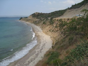
 

Journal: Chuck Spinney on Gallipoli

History, Military, War & Face of Battle
Gallipoli Today
Gallipoli Today

Above is a picture I took looking down on Anzac Cove in Gallipoli  during my recent trip to Gallipoli.  The Aussies and New Zealanders  assaulted a beach that is about 25 meters wide and 600 meters long.   After crossing the tiny beach, they hit a slope rising at about 60  degrees or more, covered by dense Mediterranean maqui.  Bear in mind,  the road in my picture did not exist and the first major summit was  probably 700-800 feet high, but to get there, you had to cross a  labyrinth of steep, irregular ravines, covered with the dense prickly  undergrowth.  Moreover, it is the wrong beach. [Continued below.]

Continue reading “Journal: Chuck Spinney on Gallipoli”

Review: GIS for Decision Support and Public Policy Making

5 Star, Best Practices in Management, Change & Innovation, Complexity & Resilience, Decision-Making & Decision-Support, Disaster Relief, Games, Models, & Simulations, Geography & Mapping, Geospatial, History, Humanitarian Assistance, Information Operations, Information Society, Information Technology, Intelligence (Government/Secret), Intelligence (Public), Peace, Poverty, & Middle Class, Stabilization & Reconstruction, Strategy, True Cost & Toxicity, Truth & Reconciliation, Values, Ethics, Sustainable Evolution, Voices Lost (Indigenous, Gender, Poor, Marginalized), War & Face of Battle, Water, Energy, Oil, Scarcity

Amazon Page
Amazon Page

ESRI Sales Material, Excellent Price, Recommended,

July 20, 2009
Christopher Thomas and Nancy Humenik-Sappington
As a publisher who is also an author, I continue to be outraged by the prices being charged for “trade” publications. This book is properly-priced–other books on GIS I would have bought are priced at three to four times their actual value, thus preventing the circulation of that knowledge. Those publishers that abuse authors and readers refuse to respect the reality that affordably priced books are essential to the dissemination of knowledge and the perpetuation of the publishing industry.

The book loses one star for refusing to address Google Earth and elements of the Google offering in this industry space. While Google is predatory and now under investigation by the anti-trust division of the Department of Justice, to ignore Google and its implications for cloud management of data in geospatial, time, and other cross- cutting contests, is the equivalent of poking one eye out to avoid seeing an approaching threat.

Having said that, I found this book from ESRI charming, useful, and I recommend it very highly, not least because it is properly priced and very well presented. Potential clients of ESRI can no doubt get bulk deliver of this volume for free.

Return on Investment factors that ESRI highlights up front include:
+ Cost and times savings
+ Increased efficiency, accuracy, productivity of existing resources
+ Revenue generation
+ Enhanced communications and collaboration
+ Automated workflows
+ More efficient allocation of new resources
+ Improved access to information.

The book consists of very easy-to-read and very well-illustrated small case studies, most previously published in Government Matters, which appears to be a journal (there are a number listed by that title).

Here are the highlights of this book for me personally:

+ Allows for PUBLIC visualization of complex data
+ Framework for “seeing” historical data and trends
+ Value of map-based dialog [rather than myth-based assertions]
+ Allows for the visualization of competing perspectives past and future
+ Illuminated land population dynamics, I especially like being able to see “per capita” calculations in visual form, especially when per capita can also be sliced by age, sex, income, religion, race, and so on.
+ Mapping derelict vessels underwater is not just a safety function, but opens the way for volunteer salvage and demolition
+ GROWS organically by attracting new data contributors who can “see” the added value of contributing their data and then being able to see their data and everyone else's data in geospatial terms. This is a POWERFUL incentive for information-sharing, which more often than not receives lip service. GIS for me is the “key” to realizing sharing across all boundaries while also protecting individual privacy
+ Shows “pockets” of need by leveraging data gaps in relation to known addresses (e.g. immunizations, beyond 5 minute fire response, etc.)'
+ Gives real meaning to “Intelligence Preparation of the Battlefield (IPB)” and–not in this book–offers enormous potential if combined with a RapidSMS web database that can received text messages from hundreds of thousands of individuals across a region
+ Eliminates the time-energy cost of data collection in hard copy and processing of the individual pages into an aggregate database.

The book discusses GIS utility in the routing of hazardous materials, but avoids the more explosive (pun intended) value of GIS in showing the public as well as government officials where all the HAZMAT is complacently stored now. For a solid sense of the awaiting catastrophe, see my review of The Next Catastrophe: Reducing Our Vulnerabilities to Natural, Industrial, and Terrorist Disasters.

The book also avoids any discussion of the urgency as well as the value of GIS in tracking and reducing natural resource consumption (e.g. water usage visible to all house by house), and the enormous importance of rapidly making it possible for any and all organizations to channel their data into shared GIS-based aggregations. For a sense of World Brain as EarthGame, see my chapter in Collective Intelligence: Creating a Prosperous World at Peace the chapter is also free online at the OSS.Net, Inc. website forward slash CIB.

This book, 189 pages of full color, is a righteous useful offering. I would encourage ESRI to become the GIS publisher of choice, buy out the titles that I could not afford, and enter the business of affordable aggregate publishing in the GIS field. Other titles by ESRI on GIS:
Measuring Up: The Business Case for GIS
The GIS Guide for Local Government Officials
Zeroing in: Geographic Information Systems at Work in the Community

Five other cool books on data pathologies that GIS can help resolve:
The Landscape of History: How Historians Map the Past
Fog Facts : Searching for Truth in the Land of Spin (Nation Books)
Lost History: Contras, Cocaine, the Press & ‘Project Truth'
Forbidden Knowledge: From Prometheus to Pornography
The Age of Missing Information (Plume)

The latter remind me that GIS will not blossom fully until it can help the humanities deal with emotions, feelings, and perceptions across tribal and cultural boundaries. Right now, 23 years after I first worked with GIS in the Office of Information Technology at CIA, GIS is ready for the intermediate leap forward: helping multinational multiagency data sets come together. ESRI has earned deep regard from me with this book and I will approach them about a new book aimed at the UN, NGOs, corporations, and governments that wish to harmonize data and in so doing, harmonize how they spend across any given region, e.g. Africa. This will be the “master leap” for GIS, enabling the one billion rich to respond to micro-needs from the five billion poor, while also increasing the impact of aggregated orchestrated giving by an order of magnitude.

ESRI: well done!

Vote on Review
Vote on Review

Click Here to Vote on Review at Amazon,

on Cover Above to Buy or Read Other Reviews,

I Respond to Comments Here or There