Guggenheim Lab: mobile lab traveling to 9 major cities over 6 yrs

Geospatial, Topics (All Other)

Currently in NYC with many free events/discussions until Oct 16.

Led by international, interdisciplinary teams of emerging talents in the areas of urbanism, architecture, art, design, science, technology, education, and sustainability, the BMW Guggenheim Lab will address issues of contemporary urban life through programs and public discourse. Its goal is the exploration of new ideas, experimentation, and ultimately the creation of forward-thinking solutions for urban life. (Will it live up to this blurb?)
http://bmwguggenheimlab.org/

Patrick Meier: Crowdsourcing Imagery Analysis

Advanced Cyber/IO, Analysis, Blog Wisdom, Collective Intelligence, Geospatial, InfoOps (IO), Methods & Process, Threats
Patrick Meier

Analyzing Satellite Imagery of the Somali Crisis Using Crowdsourcing

EXTRACT:

Here’s the plan. He talks to UNOSAT and Google about acquiring high-resolution satellite imagery for those geographic areas for which they need more information on. A colleague of mine in San Diego just launched his own company to develop mechanical turk & micro tasking solutions for disaster response. He takes this satellite imagery and cuts it into say 50×50 kilometers square images for micro-tasking purposes.

We then develop a web-based interface where volunteers from the Standby Volunteer Task Force (SBTF) sign in and get one high resolution 50×50 km image displayed to them at a time. For each image, they answer the question: “Are there any human shelters discernible in this picture? [Yes/No].” If yes, what would you approximate the population of that shelter to be? [1-20; 21-50; 50-100; 100+].” Additional questions could be added. Note that we’d provide them with guidelines on how to identify human shelters and estimate population figures.

Read more….

Koko: IBM Smart City and Portland OR Interactive Plan

Advanced Cyber/IO, Augmented Reality, Budgets & Funding, Geospatial, Government, info-graphics/data-visualization, InfoOps (IO), Intelligence (government), Methods & Process, Policies, Technologies
Koko

How does a city work? Interactive model gives Portland answers.

Rutrell Yasin

Government Computer News, 9 August 2011

How does public transportation affect education? What impact does population density have on public health? Is there a connection between CO2 levels and obesity?

Officials in the City of Portland, Ore., have collaborated with IBM to find answers to those and other questions, developing an interactive model that connects the relationships between the city’s core systems that handle the economy, housing, education, public safety, transportation and health care.

Read more.

See Also:

IBM puts its ‘smart city' technology in one package

Dolphin: Connecting to Earth Point by Point

Advanced Cyber/IO, Earth Intelligence, Geospatial

iPhone App From SimpleGeo Discovers the History, Politics & Wildlife Around You
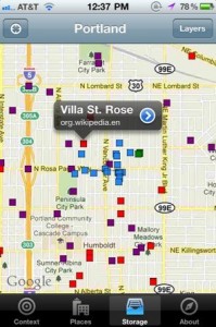

Geolocation data platform SimpleGeo released its own iOS app this morning to the app store (iTunes link). It clearly points to a future where all the data that's available online about the real-world locations we find ourselves will be available in our hands with the click of a button.

Click on Image to Enlarge

Right now, the app lets you quickly view the boundaries of geographic areas you're in (neighborhood, postal code, congressional district) and it lets you view other layers on top of your map like Wikipedia entries, Flickr photos and Project Noah wildlife sightings. Users with a SimpleGeo Storage account can log-in on the app and then view their own data layers placed on top of the map. That's pretty awesome. Now if only we could share and view each others' layers easily!

Read more….

2014 Peace from Above: Envisioning the Future of UN Air Power

Advanced Cyber/IO, Analysis, Articles & Chapters, Augmented Reality, Autonomous Internet, Briefings & Lectures, Budgets & Funding, Collective Intelligence, Computer/online security, Counter-Oppression/Counter-Dictatorship Practices, Ethics, Geospatial, History, info-graphics/data-visualization, InfoOps (IO), International Aid, Journalism/Free-Press/Censorship, Key Players, Maps, Methods & Process, microfinancing, Mobile, Non-Governmental, Peace Intelligence, Policies, Policy, Real Time, Reform, Serious Games, Strategy, Technologies, Threats, Tools
Click on Image to Enlarge

Short URL: http://tinyurl.com/UNODIN

Steele in Dorn Peace from Above As Published

Finally published in 2014 (Article) originally presented in 2011 (Briefing).

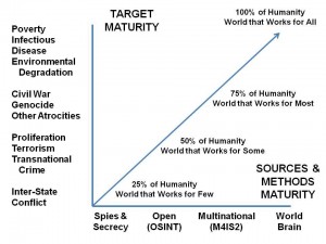
The chapter more fully integrates the DNI spiral between modern mature intelligence (M4IS2) and modern mature Air Power.

Abstract 3.1

Briefing 3.3 (29 Slides With Notes As Presented 40 KB pptx)

Event: 15-17 June Ontario UN Aerospace Power

See Also:

2012 Robert Steele: Practical Reflections on UN Intelligence + UN RECAP

UN Intelligence @ Phi Beta Iota

Worth a Look: Wings for Peace – First Book on Air Power in UN Operations

Marcus Aurelius: Global Phone-Tracking Blown Big Time….

10 Security, 11 Society, Advanced Cyber/IO, Commerce, Commercial Intelligence, Geospatial, Government, Law Enforcement, Military, Mobile, Real Time
Marcus Aurelius

I recall that Viet-Nam era secret writing was blown by an Admiral in his memoirs, causing all future terrorists and secret police to photocopy incoming and outgoing mail.  This appears to be publicity we could have done without.

Meet the ‘Keyzer Soze’ of Global Phone-Tracking

Spencer Ackerman

WIRED, July 18, 2011

‘The capability of doing mass tracking is possible.’

EXTRACT

Around the world, TruePosition markets something it calls “location intelligence,” or LOCINT, to intelligence and law enforcement agencies. As a homeland security tool, it’s enticing. Imagine an “invisible barrier around sensitive sites like critical infrastructure,” such as oil refineries or power plants, TruePosition’s director of marketing, Brian Varano, tells Danger Room. The barrier contains a list of known phones belonging to people who work there, allowing them to pass freely through the covered radius. “If any phone enters that is not on the authorized list, [authorities] are immediately notified.”

Read full article…

In “borderless” cyberspace, nation states struggle — M4IS2 Anyone?

Advanced Cyber/IO, Analysis, Augmented Reality, Budgets & Funding, Collective Intelligence, Communities of Practice, Computer/online security, Corporations, Counter-Oppression/Counter-Dictatorship Practices, Cultural Intelligence, Earth Intelligence, Ethics, Geospatial, History, info-graphics/data-visualization, InfoOps (IO), Intelligence (government), Journalism/Free-Press/Censorship, Key Players, Methods & Process, Officers Call, Peace Intelligence, Policies, Policy, Politics of Science & Science of Politics, Real Time, Reform, Research resources, Serious Games, Standards, Strategy, Technologies, Threats, Tools, Whole Earth Review
Click on Image to Enlarge

Analysis: In “borderless” cyberspace, nation states struggle

By Peter Apps, Political Risk Correspondent

Reuters LONDON | Thu Jun 9, 2011

EXTRACT:

“The nature of cyberspace is borderless and anonymous,” R. Chandrasekhara, secretary of India's telecommunications department, told a cyber security conference in London last week organised by a U.S.-based think tank, the EastWest Institute. “Governments, countries and law — all are linked to territory. There is a fundamental contradiction.”

Read full article….

Tip of the Hat to Chris Pallaris at LinkedIn.

Phi Beta Iota: The national secret intelligence communities mean well, but they are cognitively and culturally incapacitated  in relation to both the global threats and the global infomation sharing and sense-making possibilities.  It may just be that the solution has to come from a private sector service of common concern that can provide the integrity now lacking in governments and most corporation.  Scary thought.  M4IS2 is inevitable….delay is costing trillions.