Worth a Look: CrowdMap (Beta)

Advanced Cyber/IO, Analysis, Augmented Reality, Citizen-Centered, Collective Intelligence, Collective Intelligence, Counter-Oppression/Counter-Dictatorship Practices, Earth Intelligence, Geospatial, Historic Contributions, info-graphics/data-visualization, InfoOps (IO), Intelligence (government), International Aid, IO Mapping, Journalism/Free-Press/Censorship, Maps, Methods & Process, microfinancing, Mobile, Officers Call, Open Government, Policy, Reform, Research resources, Technologies, Tools, Worth A Look

Crowdmap (Liquida)

Crowdmap allows you to…

+ Collect information from cell phones, news and the web.
+ Aggregate that information into a single platform.
+ Visualize it on a map and timeline.

Crowdmap is designed and built by the people behind Ushahidi, a platform that was originally built to crowdsource crisis information. As the platform has evolved, so have its uses. Crowdmap allows you to set up your own deployment of Ushahidi without having to install it on your own web server.

See Also:

Graphics: Twitter as an Intelligence Tool

Reference: How to Use Twitter to Build Intelligence

Journal: Tech ‘has changed foreign policy’

Continue reading “Worth a Look: CrowdMap (Beta)”

Video: “Twinkie Deconstructed” Author Shows Strange Origins & Nexus of Ingredients

07 Health, Advanced Cyber/IO, Commerce, Graphics, True Cost, True Cost, Videos/Movies/Documentaries
From TwinkieDeconstructed.com

In this fascinating exploration into the curious world of packaged foods, Twinkie, Deconstructed takes us from phosphate mines in Idaho to corn fields in Iowa, from gypsum mines in Oklahoma to oil fields in China, to demystify some of America’s most common processed food ingredients—where they come from, how they are made, how they are used—and why. Beginning at the source (hint: they’re often more closely linked to rocks and petroleum than any of the four food groups), Steve Ettlinger reveals how each Twinkie ingredient goes through the process of being crushed, baked, fermented, refined, and/or reacted into a totally unrecognizable goo or powder with a strange name—all for the sake of creating a simple snack cake.

Continue reading “Video: “Twinkie Deconstructed” Author Shows Strange Origins & Nexus of Ingredients”

Graphic: “The True Cost of Coal”

01 Agriculture, 03 Economy, 03 Environmental Degradation, 05 Energy, 07 Health, 10 Security, 12 Water, Civil Society, Earth Intelligence, Graphics, Peace Intelligence, True Cost, True Cost

See the graphic and the process by the Beehive Design Collective

After two years of collaborative research, storysharing, metaphor crafting, and meticulous illustrating, the bees have completed an epic illustration about mountaintop removal coal mining.

See the graphic and process by the Beehive Design Collective

Related:
+ True Cost Meme
+ True Cost T-Shirt

Building an Audio Collection for All the World’s Languages

04 Education, Academia, Audio, Civil Society, Cultural Intelligence, Languages-Translation
Long Now post

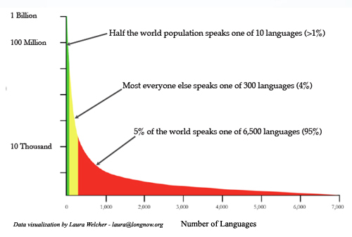
The Rosetta Project is pleased to announce the Parallel Speech Corpus Project, a year-long volunteer-based effort to collect parallel recordings in languages representing at least 95% of the world’s speakers. The resulting corpus will include audio recordings in hundreds of languages of the same set of texts, each accompanied by a transcription. This will provide a platform for creating new educational and preservation-oriented tools as well as technologies that may one day allow artificial systems to comprehend, translate, and generate them.

Continue reading “Building an Audio Collection for All the World’s Languages”

U.S. Geological Survey: Twitter Earthquake Detector (TED)

03 Environmental Degradation, 10 Security, Citizen-Centered, Civil Society, Collective Intelligence, Earth Intelligence, Geospatial, Geospatial, Government, Graphics, Media

People can receive earthquake data from the @USGSTED Twitter account. The site sends maps of earthquake zones to account holders.

U.S. Geological Survey: Twitter Earthquake Detector (TED)

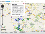
Sample map output from the Twitter Earthquake Detector prototype  project.

The U.S. Geological Survey is using funds from the American Recovery and Reinvestment Act to support a student who’s investigating social Internet technologies as a way to quickly gather information about recent earthquakes.

In this exploratory effort, the USGS is developing a system that gathers real-time, earthquake-related messages from the social networking site Twitter and applies place, time, and key word filtering to gather geo-located accounts of shaking. This approach provides rapid first-impression narratives and, potentially, photos from people at the hazard’s location. The potential for earthquake detection in populated but sparsely seismicly-instrumented regions is also being investigated.

Social Internet technologies are providing the general public with anecdotal earthquake hazard information before scientific information has been published from authoritative sources.  People local to an event are able to publish information via these technologies within seconds of their occurrence. In contrast, depending on the location of the earthquake, scientific alerts can take between 2 to 20 minutes. By adopting and embracing these new technologies, the USGS potentially can augment its earthquake response products and the delivery of hazard information.
Reference: Mini-Atlas of Human Security

01 Poverty, 06 Family, 07 Other Atrocities, 08 Immigration, 10 Security, 11 Society, Academia, Cultural Intelligence, Non-Governmental, Peace Intelligence, Strategy-Holistic Coherence
Berto Jongman Recommends...

Phi Beta Iota: One day the World Map ofConflict & Human Rights pioneered by Berto Jongman will return–it is a travesty that his official duties do not allow him to continue this hugely significant endeavor.  In the interim, he recommends, as do we, the below effort.

The miniAtlas of Human Security

An at-a-glance illustrated guide to global and regional trends in human insecurity, the miniAtlas provides a succinct introduction to today’s most pressing security challenges. It maps political violence, the links between poverty and conflict, assaults on human rights—including the use of child soldiers—and the causes of war and peace.

The miniAtlas is available in print and online in English, French and Spanish. The miniAtlas is also available in print in Russian and Japanese. It will be available online in these languages in the summer of 2010.

Home Page

See Also:

Graphic: Simplified World Conflict Map

Graphic: Global Threats to Local Survival (1990′s)

Search: world map with 8 conflicts

Search: world map with conflict marked other maps

Search: The Future of OSINT [is M4IS2-Multinational]